25 Years of Travel Photography - My favourite shots from my travels
This article features a selection of my favourite photographs taken during my travels during the past 25 years, either because it's a particularly good memory or I was particularly happy with the photo I took.
TRAVEL
One of my passions is photography, especially travel photography. I have never really had any fancy gear and have just relied on my Google Pixel by and large lately, which works fine. I think the fanciest piece of kit I ever owned was a Sony NEX, but that's all. But that doesn't stop me from enjoying creating photographic memories of my travels around the world, in fact when I am just equipped with a phone, I tend to take more pictures because it's a faff to carry camera equipment.
This page features some of my favourite photos and favourite memories from my travels. Where I have written about our travels for that particular picture, I inlude a link to that blog post.

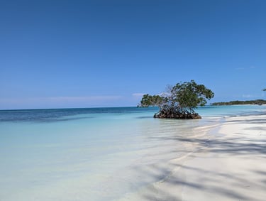
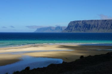
A solitary tree on a beach on Cayo Jutías near Viñales, Cuba.
This photo always brings back nice memories as one of the most memorable and special things we did during our visit to Cuba. Driving there in an old American car, across the causeway and to this paradise island was really special. The white sand was like powder, the sea was warm. A guy walked along the beach selling cold beer, and a couple of guys had set up a BBQ where they sold delicious grilled lobster, which we ate while sitting on the beach. [link to our Cuba blog]

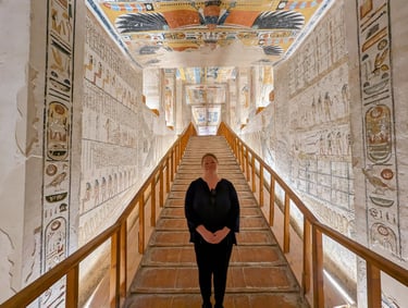
Tomb KV9 in Valley of the Kings, Egypt
I never understood what the whole fuss was about Valley of the Kings until we got there. When you search "Valley of the Kings" in Google, there isn't anything particularly striking that comes up. However, we purchased additional tickets to go and see tomb KV9, which is a combined tomb of Ramesses V and Ramesses VI. What is most striking about the tombs in Valley of the Kings, and just achaeological sites in Egypt in general, is just how incredibly well preserved everything is, it really blows your mind, along with the sheer scale of everything. This particular tomb was for kings that reigned over 3100 years ago. Imagine that, and you can't help but be blown away by the interior of these tombs. Everybody talks about seeing the pyramids of Egypt as their #1 attraction they want to see in Egypt. But really, the temples and tombs are way more impressive. [link to our Egypt blog]
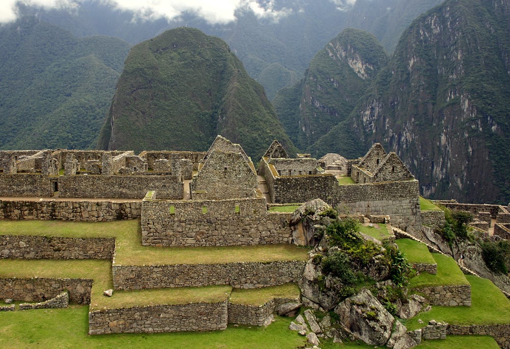
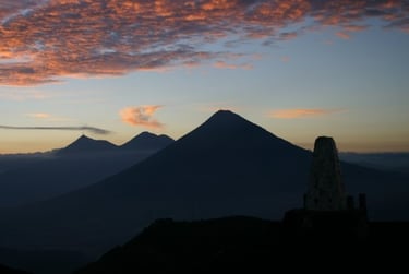
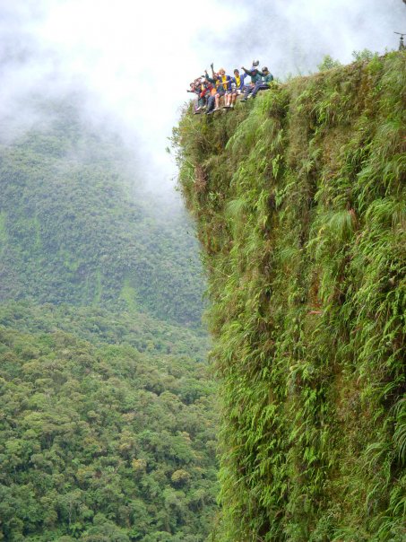
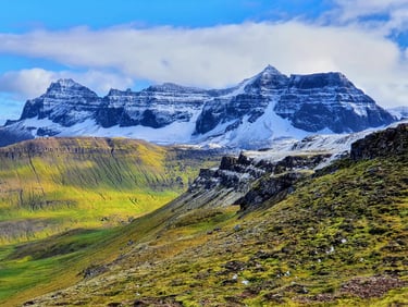
Clouds lifting over the mountains surrounding Machu Picchu, Peru
I did the 4 day Inca Trail trek back in 2007 with a company called Peru Treks. On the 4th day, we got up in the middle of the night and started trekking through the jungle towards our final destination, Machu Picchu, which we were meant to get to before sunrise so that we could watch the sun rise above the ruins. However, it was very rainy that night and we arrived at Machu Picchu completely shrouded in clouds. Zero visibility. We persevered though, and while we did not see the sunrise, we saw the magical moment as the clouds started to lift from the ruins and then the sorrunding mountains. The landscape surrounding Machu Picchu are as impressive, if not even more impressive than the ruins themselves. You really have to be there to get how incredibly dramatic and stunningly beautiful the place is.
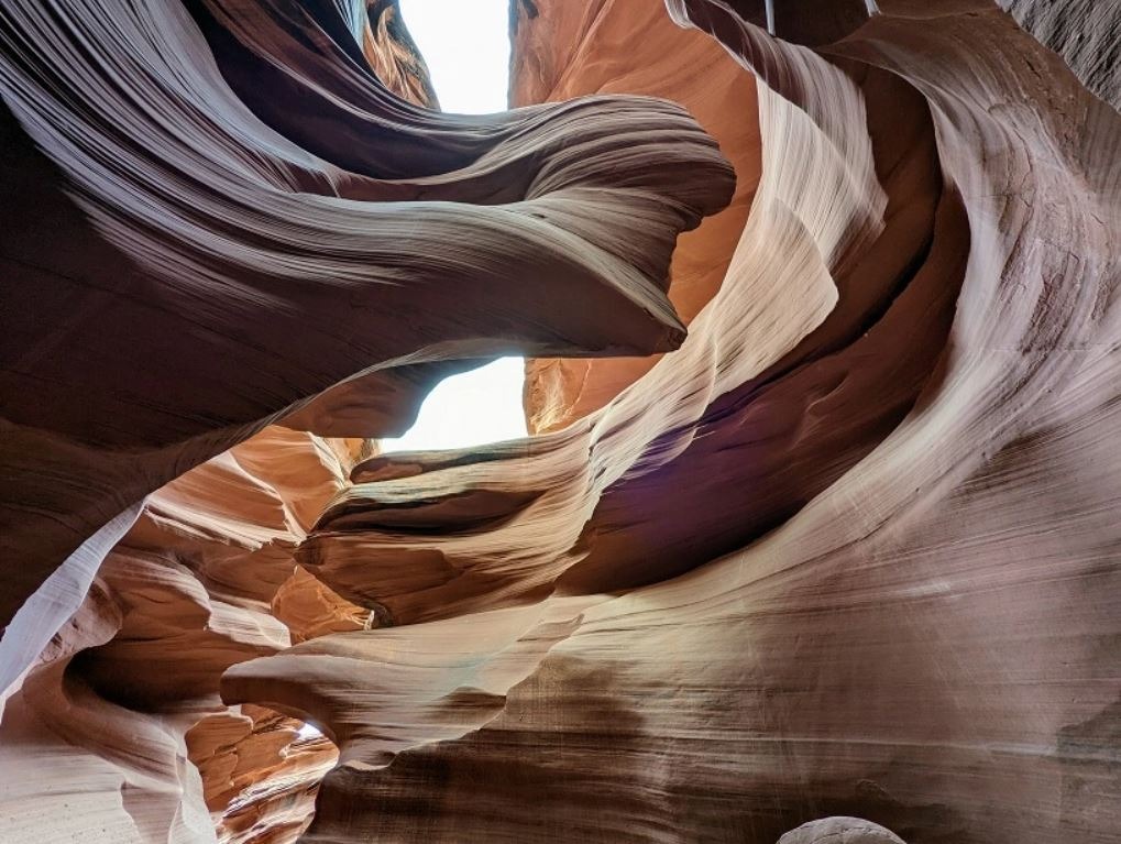
The many sandstone formations of Antelope Canyon
I was told about Antelope Canyon by a coursemate during my MSc course in hydrogeology at University of Strathclyde, but she was planning to go there. When I looked the place up, I could see that I recognised the place from screensavers I had admired many, many times but never knew what place these photos were from. There's an "Upper Antelope Canyon" and a "Lower Antelope Canyon". Upper Antelope Canyon, which is the more famous and in-demand section of Antelope Canyon because of its iconic light beams and easier accessibility, receives more visitors overall than Lower Antelope Canyon. We decided to visit Lower Antelope Canyon and it definitely did not disappoint, the walkthrough the canyon was absolutely spectacular.
The canyon is carved into Navajo Sandstone, which was originally formed from ancient sand dunes about 190 million years ago. Although the region is a desert, heavy rains (often far away) periodically sent sudden, powerful floods through narrow cracks in the rock. Although the region is a desert, heavy rains (often far away) periodically sent sudden, powerful floods through narrow cracks in the rock. Floodwaters carried sand and debris that acted like sandpaper, gradually scouring, smoothing and widening the passageways. Because the cracks were narrow, erosion worked mostly downward rather than outward, creating the canyon’s deep, twisting, wave-like walls. Wind also helped shape the softer sandstone, refining the curves and textures over time. This process has been on repeat for over millions of years, creating the stunning naturally formed sand sculptures in the slot canyon. [link to our southwest USA roadtrip blog]

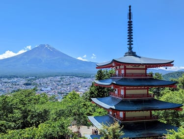
Chureito Pagoda overlooking the northern slopes of Mt. Fuji, Japan
Japan is ridiculously photogenic, as standard, but we were so lucky to get this absolutely perfect weather when we went to the Fuji Five Lakes area north of Mt. Fuji. You see Fuji-san from wherever you are in this region, but one of the absolutely most photogenic and picturesque place is from Chureito Pagoda which is within easy walk (albeit hot and stuffy in summer) from Shimoyoshida Station just east of Fujikawaguchiko. In the cherry blossom season in spring or during the autumn colours, this place becomes even more stunning than when we were there in summer. [link to our Japan blog]
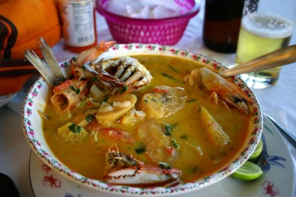

Tapado traditional dish in Livingston, Guatemala
This photo isn't any kind of masterpiece, but this dish certainly is! I was on my own travelling in Guatemala back in 2006 and had just arrived in Livingston, a seaside town by the Caribbean side of Guatemala. I sat down at a restaurant and didn't really know what to order from the menu, but the waitor suggested I try a dish called "Tapado". It turned out to be one of the most incredibly flavoursome, tasty dishes that I had ever tasted. It was so unexpected. Absolutely delicious.
Tapado is a rich, coconut-based seafood stew deeply rooted in Garífuna cuisine, made by simmering a variety of fresh seafood, commonly fish, shrimp, crab, lobster or conch together with green plantains, ripe plantains, yuca and sometimes potatoes in a fragrant broth of coconut milk, garlic, onions, bell peppers, tomatoes and local herbs and spices; the result is a hearty, aromatic dish that balances savory seafood flavors with subtle sweetness from the coconut and plantains, typically served hot with rice and reflecting the Afro-Caribbean cultural influences of Guatemala’s Caribbean coast.
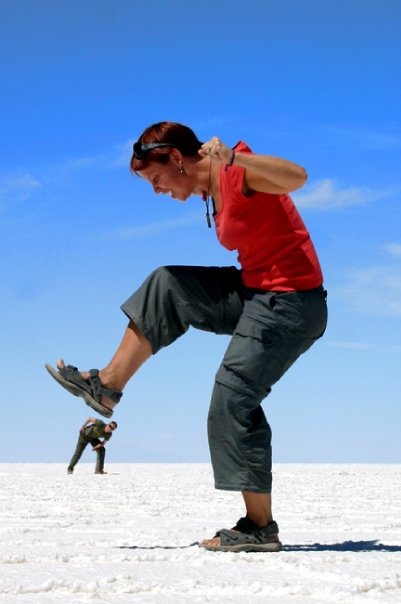
Salar de Uyuni saltflats of Bolivia during the dry season
The first time I went to Bolivia in 2007, I went on a tour from Tupiza in southern Bolivia near the Argentinian border to Uyuni in southwestern Bolivia via the absolutely stunning Bolivian altiplano, a high-elevation plateau in the Andes covered in volcanos, colourful lakes, Andean flora and fauna and indigenous people who live at this extreme elevation. One of the main attractions on these tours is the Salar de Uyuni salt flats. In the dry season, the salt flats are blindingly white and flat as far as the eye can see and you can play all sorts of visual illusions with photographs, like in the above photograph where my travel buddies Lee is pretending to be crushing miniature-sized Kristian. I have lots of photos like this, and lots of people do. Some fun memories. If you go here in the wet season on the other hand, the salt flats are covered in a thin layer of water, creating what looks like an endless mirror as far as the eye can see.


Kayan woman in Nai Soi, Thailand
I travelled to Thailand just a few days after the 2004 Boxing Day tsunami that hit the western coast of Thailand, including Phuket, Koh Phi Phi, Koh Lanta and many other island and coastal areas really badly. I already had a flight to go to Thailand before the tsunami happened, but rather than going to the coastal cities in the southwest, I travelled to the mountainous north. While I was there, I visited a refugee community of the Kayan people in Nai Soi next to the Myanmar border. This is where I took this picture of this beautiful young woman who was selling handcrafted souvenirs in the village.
The Kayan people are an ethnic subgroup of the wider Karen peoples originally from eastern Myanmar (Burma). The community that live in Nai Soi in Mae Hong Son Province, northwestern Thailand, largely consists of refugees and descendants of refugees who fled conflict in Myanmar beginning in the late 1980s and 1990s. They are known for the brass neck coils worn by some women, a cultural tradition that begins in childhood and gradually increases in weight, creating the appearance of an elongated neck (the effect is actually caused by compression of the collarbone and ribcage rather than stretching of the neck itself).
I have not been back since then, but from what I've read, some residents have left Nai Soi in recent years, resettled to third countries, integrated elsewhere in Thailand or chosen to stop wearing the coils, reflecting changing attitudes, generational shifts and evolving political conditions.


La Diablada Festival in Oruro, Bolivia
I was lucky enough to be in Bolivia at the same time as the Diablada festival took place in Oruro in the south of Bolivia, where I took this photo from the parade. The festival happens annually during Carnival season, typically in February or March. La Diablada is a dramatic and colorful traditional dance and festival most famously performed during the Carnaval de Oruro in Bolivia, blending pre-Columbian Andean beliefs with Spanish Catholic symbolism. At its center is a theatrical portrayal of the battle between good and evil, where elaborately costumed dancers wearing ornate devil masks represent demons led by Lucifer, while figures such as the Archangel Michael, angels, and saints embody Christian forces of good. The dance draws heavily from ancient Uru and Aymara cosmology, particularly the worship of Supay, the Andean lord of the underworld and mines, which was later merged with Catholic ideas of hell and the Virgin Mary, especially the Virgin of the Mines (Virgen del Socavón).
When you attend the dance show parade, you sit on benches on either side of the parade. Everybody gets drunk and there's a tradition of throwing water balloons at each other in the audience (not at the dancers, obviously). It's great fun and a chance to get to know local Bolivian.
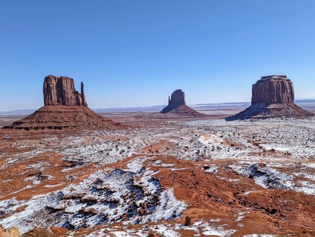

Monument Valley, Arizona, USA
This photo is maybe a bit of a cliché, but it nevertheless is one of my best travel memories to date. We've all seen this view on photographs or in movies or TV shows, it is such an iconic place and I thought that when I'd get there, it would just be a bit "meh, seen that a million times and it's just like the pictures", but it really isn't. There's this drive you can do around Monument Valley called the 17 Mile Loop which takes you along a dirt track all around the different rock formations like the Mittens and John Ford's Point, typically taking 2-4 hours and requiring a fee to access. While a high-clearance or 4WD vehicle is recommended for the sandy, rough terrain, many manage in standard cars in dry conditions, but it's risky in wet weather. We were actually really lucky to even get to go on the loop route, as it was closed when we first arrived due to snowy and wet conditions, but just as we were about to leave Monument Valley, they opened the loop to 4WD vehicles, which fortunately we had! If you are doing an Arizona roadtrip, definitely make sure you got a vehicle suitable for the conditions, because the 17 Mile Loop is one you should definitely not miss! [link to our southwest USA roadtrip blog]

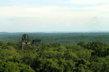
The Mayan ruins of Tikal in the Peten forest of northern Guatemala
I was in Guatemala back in 2006 and one of the many places I visited was the famous Mayan archaeological site of Tikal. Tikal is one of the largest and most important ancient Maya cities, located deep in the rainforests of northern Petén, Guatemala, and flourished roughly from 600 BCE to 900 CE. At its height, Tikal was a powerful political, military, and religious center, rivaling other major Maya cities such as Calakmul. The site is famous for its soaring limestone temple, especially Temple I (Temple of the Great Jaguar) and Temple IV, one of the tallest pre-Columbian structures in the Americas, as well as expansive plazas, palaces, causeways, and thousands of carved stelae and altars that record dynastic history. Today, Tikal is both a UNESCO World Heritage Site and part of Tikal National Park, valued for its extraordinary combination of archaeology and biodiversity.
Nowadays, climbing up the ruins is largely prohibited, so while I can't say for certain, but this incredible view of the ruins sticking out of the jungle may not be visible anymore. I just remember standing there in awe, looking at the jungle as far as the eye could see.
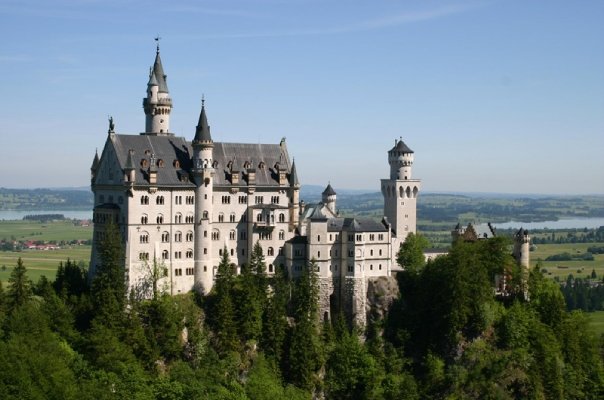
Neuschwanstein Castle in southern Germany
Me and my friend Hildur went on an Interrail trip across Europe when we were 21 years old in the summer of 2005. We flew into Frankfurt in Germany and back home from Krakow in Poland, taking the train through southern Germany, Switzerland, Austria, Czechia (then the Czech Republic), Poland as well as a bus trip into Liechtenstein. We fell in love with Switzerland as a whole, but two of the most impressive destinations we went to on our trip was to Hallstatt in Austria Neuschwanstein Castle in southern Germany, shown in the picture above.
Neuschwanstein Castle is a 19th-century Romanesque Revival palace built by King Ludwig II of Bavaria beginning in 1869. It is perched dramatically on a rocky hill above the village of Hohenschwangau and was inspired by medieval legends, Wagnerian operas and Ludwig’s romantic vision of kingship rather than by practical defense. The castle features fairy-tale towers, lavishly decorated interiors and advanced technology for its time, such as running water and central heating. Although never fully completed and lived in by Ludwig for only a short time before his mysterious death in 1886, Neuschwanstein became one of Europe’s most famous landmarks.
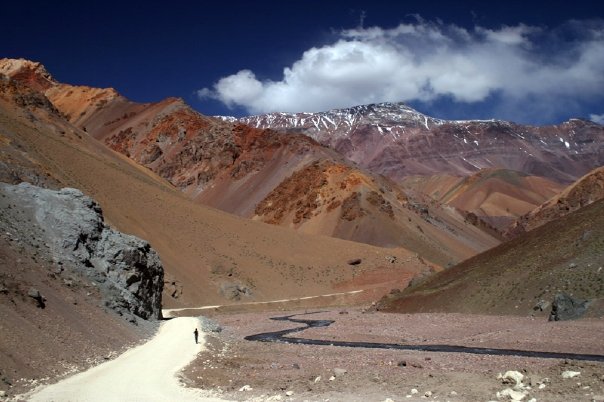

Paso Agua Negra in Chile
I took this photo back in 2008 when I was about to start university in the village of Villa Union in La Rioja province of northwestern Argentina. I had spent the 2007/2008 South American summer in La Serena in Chile and my good friend Noler offered to drive me over the border to the other side, but the Paso Agua Negra border connects the Chilean region of Coquimbo with the Argentinian region of San Juan, which is adjacent to La Rioja province. A few friends came along for the ride as well and we made it a spectacular and fun tour with friends. I have never before, nor after, seen any landscape that was just so incredibly strikingly beautiful, colourful and dramatic. The colours of the mountains were just insane. I dream about going back with a rental car and exploring this region at a more leisurely pace one day when we're back in Chile. A photographer's paradise.
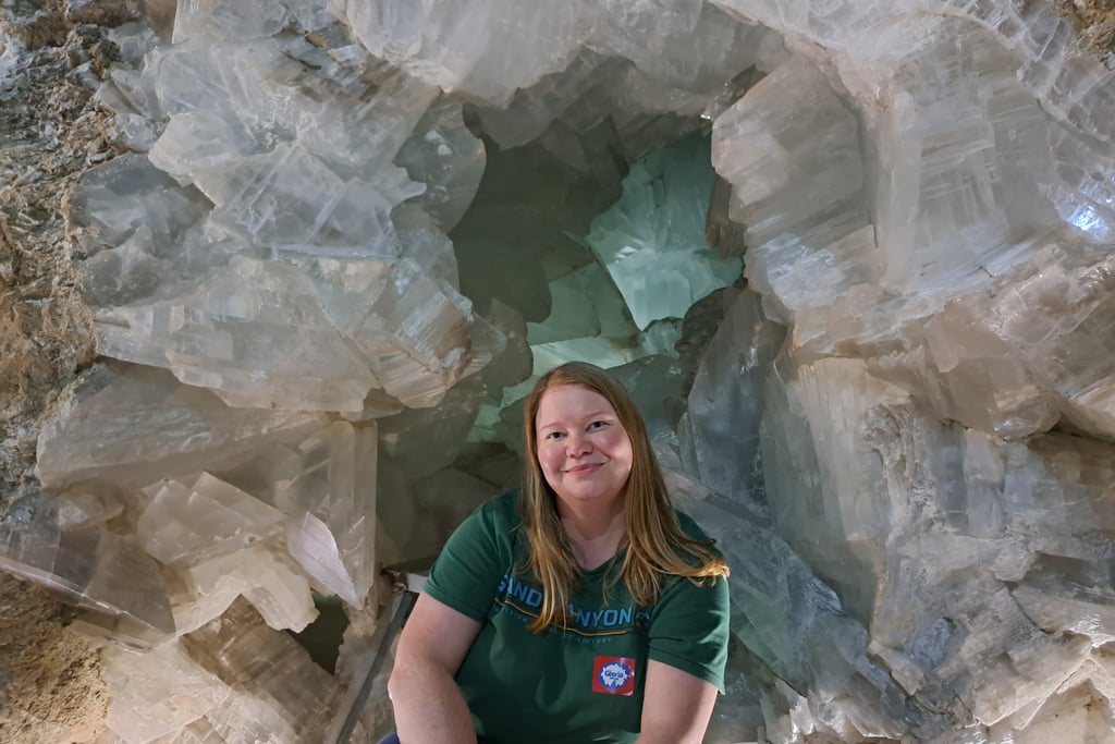
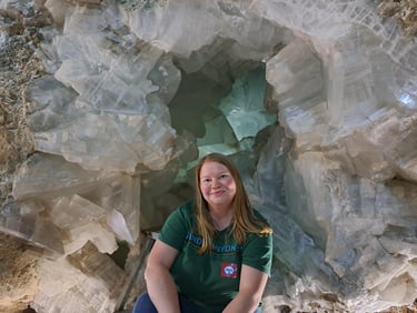
Geoda de Pulpi in Spain
The Pulpí Geode (Geoda de Pulpí) is a spectacular natural geological formation hidden deep inside the old Mina Rica silver‑lead mine near Pulpí in Andalusia, Spain near the border of Murcia. It was discovered in December 1999 by mineralogists from the Grupo Mineralogista de Madrid. It is one of the largest documented geodes in the world and widely regarded as the largest accessible geode you can visit anywhere. Unlike the small geodes you might see in rock collections, this one is huge: it measures about 8 m long, 1.7–1.8 m high and fills roughly 10.7 m³ of space. Its interior walls are completely lined with enormous, translucent gypsum crystals (a form of selenite) that can reach nearly 2 m in length and are remarkable for their clarity and perfection.
The geode formed over millions of years through a combination of karstic dissolution of surrounding dolomite rock and later mineral‑rich waters depositing gypsum crystals inside the cavity, creating a glittering chamber of immense natural beauty. After extensive conservation and safety work, guided tours opened to the public in 2019, but I had been wanting to see this incredible one-of-a-kind place ever since I learned about it and in 2023 this dream became reality. The photo above is me sitting with a big wide happy smile in front of this incredible wonder that is the Pulpi Geode.
The tours are really reasonably priced and totally value for money, but you get a big tour through the mine itself, which is stunning and super interesting in its own right. You then descent into the "crystal chamber" of the geode, where people go, one by one, sticking their head into the geode. No photographs are allowed inside the geode itself
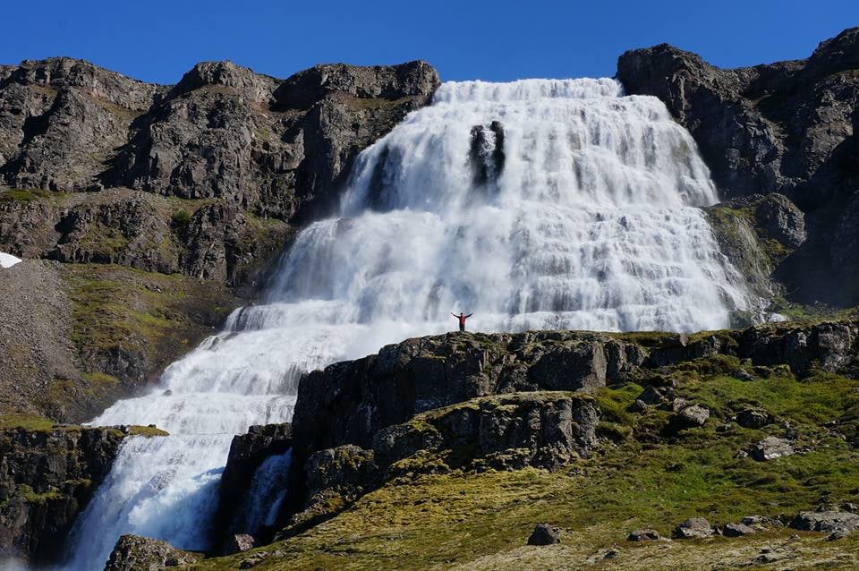
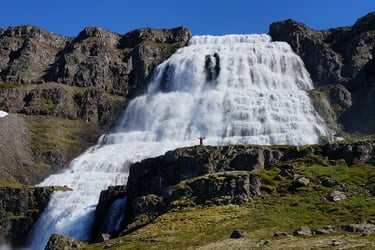
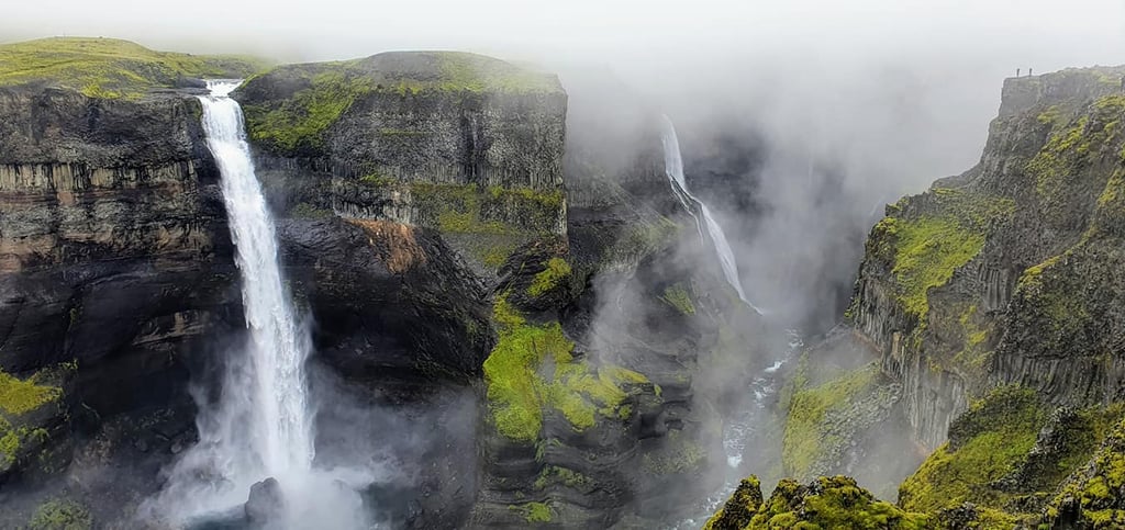
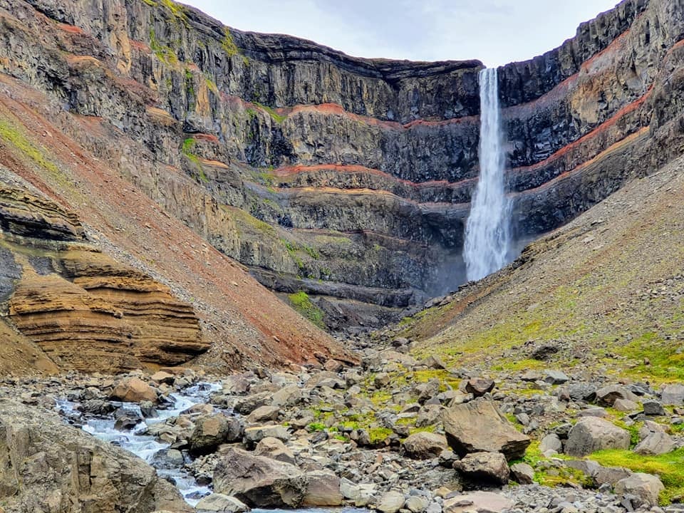
Dynjandi Falls in the Westfjords of Iceland
Iceland has its fair share of spectacular waterfalls. So many that my grandmother had a book called "The Waterfalls of Iceland" and it was huge! I have, by this point, seen the vast majority of waterfalls worth seeing in Iceland but the one that definitely impressed me the most was the Dynjandi Falls in the Westfjords of Iceland, shown in the picture above. I had seen plenty of photographs of the waterfall, but nothing really prepares you for the sheer scale of the falls. The fall off the top of a basalt cliff and spread out like a bride's veil in this beautiful cascading way. You can see Joe standing there at the front of the falls for some sort of scale. He's standing several meters ahead of the falls, if he was closer he'd look even tinier.
But the falls aren't just this single waterfall you see in the photograph, there are numerous other waterfalls cascading below it which couldn't be captured in one single photo. The place is genuinely just so impressive!

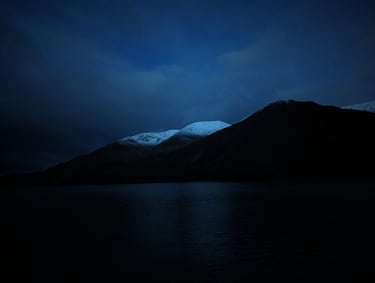
The first snow of the year at Coire Glas in Scotland
I spent a year and a half working as a tunnel geologist on the Coire Glas exploratory tunnel project in the highlands of Scotland during 2023-2024. The shifts were long, 7am to 7pm or 7pm to 7am, and getting to site required commuting from Spean Bridge on the A82, driving along the shores of Loch Lochy. Because of the time of day I was driving, I often got really weird and/or spectacular light conditions for taking photographs, one of which is this one in the early hours of the morning and we just got the first snow. I just thought the landscape looked so eerie, I just had to stop and take a picture.
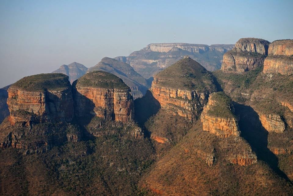
The Three Rondavels in Blyde River Canyon of South Africa
I travelled to South Africa in 2016 to award myself with a trip to the International Geological Congress that was held in Cape Town, South Africa that year. One of the main reasons why I signed up for the congress was so that I could go on the geological excursion, which had numerous world-hit geological sites that are just out of this world! South Africa has some of the most interesting geology on the planet and this trip was one of the most memorable ever in living memory. One of the many spectacular places that we went to was Blyde River Canyon, including a stop at the spectacular viewpoint of the Three Rondavels, shown above. Rest assured, there will be numerous other photos from this trip in this article I've written!
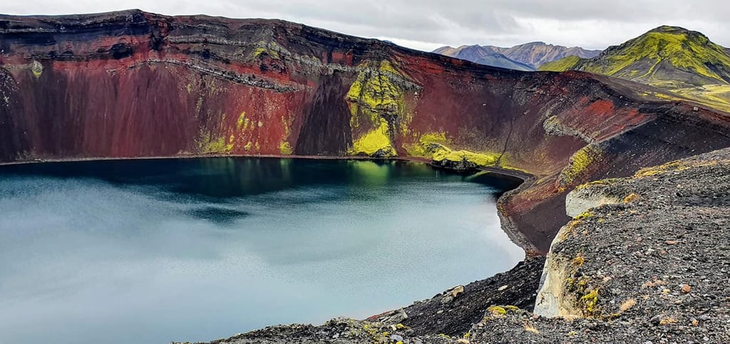
Ljótipollur crater lake in the southern highlands of Iceland
The southern highlands of Iceland are my happy place. They are so stunning and so utterly different fromthe rest of the country, with incredibly dramatic scenery all around which constantly changes depending on the time of day and the weather. It is a photographer's paradise. Ljótipollur is located close to the famous tourist destination Landmannalaugar, known for incredibly impressive volcanic landscape and geothermal pool. I got really lucky with the lighting when we visited Ljótipollur crater lake back in 2021. The red scoria and the yellowish green moss appeared brighter than ever. It's actually quite funny that the crater lake is called "Ljótipollur", which in Icelandic means "Ugly Puddle" but it couldn't be furtherfrom the truth!

Sunset from the top of Pacaya Volcano in Guatemala
When I was in Guatemala back in 2006 I went on a tour from the city of Antigua to climb up to the top of Pacaya volcano, but the tour stays on the mountain until sunset and we then walked back down in the dark. While walking in the darkness wasn't ideal, the sunset view over the many other volcanoes surrounding the Antigua region was absolutely incredible.

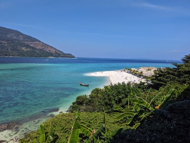
North Point Beach on Koh Lipe, Southern Thailand
If there is paradise on Earth, for me it is the island of Koh Lipe in southern Thailand. The island is absolutely tiny and is closer to Malaysia than Thailand. It is extremely different from Malaysia though, as there is plenty of booze and Thai food. The beaches are just out of this world, so is the warm ocean that is crystal clear. The vibe on the island is so incredibly chilled and we dream about going back one day and spending some more time there. This particular photo is taken from the restaurant at our hotel on North Point Beach called the Mountain Resort, and it's one of the most famous and striking beaches on the island. To get to Koh Lipe, you typically either take a fairly straight-forward ferry from the island of Langkawi, or quite a scary long speedboat trip to Koh Lanta, Koh Phi Phi or Krabi. I believe there are some shorter boat rides available to the mainland Thailand but that adds a lot of overland travel time instead, leaving you in a very awkward part of Thailand to get around. [link to our Southeast Asia blog]
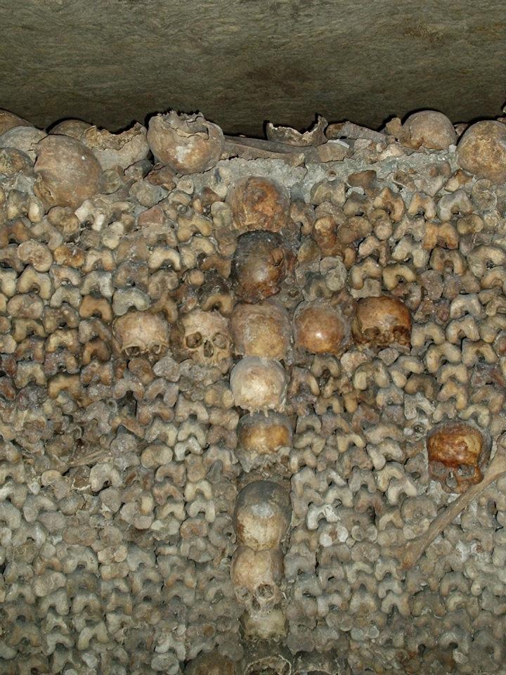
Catacombs of Paris
I went to France on a student exchange programme through my college in Iceland back in 2004. A French student came to stay with me for a week and I stayed with her and her family in France for a week. We also had a bit of time at the start of our stay to see Paris. One of the places we were taken to was the Catacombs of Paris. The Catacombs of Paris are an extensive network of underground tunnels and ossuaries beneath the streets of Paris, created in the late 18th century to address overflowing cemeteries. Originally limestone mines, the tunnels were repurposed starting in 1786 to house the remains of millions of Parisians, transferred from cemeteries. Today, the Catacombs contain the bones of an estimated 6–7 million people, carefully arranged along walls in decorative patterns, including stacks, crosses, and skull motifs. The official public route, about 1.5 kilometers long, is open for tours, while the entire subterranean network spans hundreds of kilometers, much of it illegal or restricted to urban explorers.
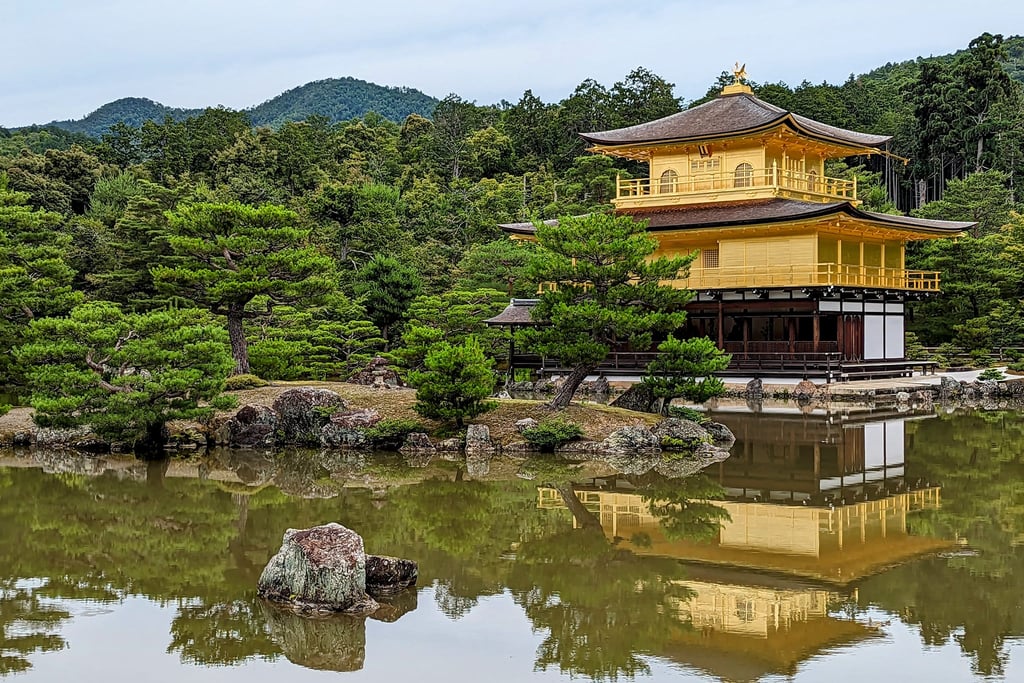
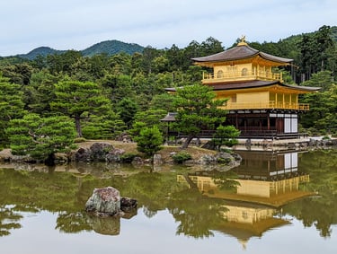
Kinkaku-ji Golden Pavilion in Kyoto Japan
When I was a child, I had this penpal from Saitama near Tokyo in Japan called Yoshi. He often sent me postcards from Japan and one that always stuck out for being particularly impressive was a postcard of the Golden Pavilion in Kyoto. It was this mystical place in my mind, something so out of this world... this beautiful temple covered in gold, with a perfect mirror reflection of the temple in the lake next to it, surrounded by beautiful gardens. When I was little I could only dream about seeing this place, so when me and Joe went to Japan back in 2023, I just had to go and see this incredible place. The place is called Kinkaku-ji in Japanese and is a Zen Buddhist temple located in in Kyoto. It is designated as a World Heritage Site, a National Special Historic Site, a National Special Landscape, and one of the 17 Historic Monuments of Ancient Kyoto. [link to our Japan blog]
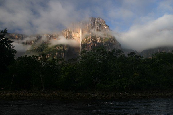
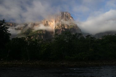
Watching the sunrise in front of Angel Falls, Venezuela
I travelled to Venezuela at the end of 2007 as I made my way from Argentina to Colombia through Bolivia, Brazil and Venezuela. I had't really had any particular plans for Venezuela, I was just travelling by the cheapest means possible to go to see the girl I sponsored through Children International who lives in Barranquilla in Colombia. However, once I got to Venezuela, I realised I had greatly underestimated the country. When you land in Venezuela after the Brazilian land border, you find yourself in this town called Santa Elena de Uairen. What I didn't know is that this town is a tourism hub to all the wonderful places of south of Venezuela, including the Gran Sabana and the tepui of Roraima (a table top mountain), among other tours. I was also able to learn how I could actually get an opportunity to see Angel Falls, the highest single-drop waterfall in the world, located in Canaima National Park.
I took a bus from Santa Elena to Ciudad Bolivar, from where I took a flight to Canaima and there boarded a motorised boat that would take us sightseeing around the national park. We slept in hammocks in an open air space with a roof to shelter us from rain, located right in front of Angel Falls, so when we woke up, we could see the falls at sunrise, which was utterly spectacular. The landscape all over southern Venezuela is just like out of some kind of fairytale.

Death Road on a bike in Bolivia
The Death Road in Bolivia is a notoriously steep and treacherous route stretching about 64 kilometers from La Paz to Coroico through the Andes. It was built in the 1930s by Paraguayan prisoners and gained the nickname “Death Road” due to its narrow single lanes, sheer cliffs up to 600 meters, frequent landslides, and historically high fatality rate. Today, the road is a popular adventure tourism destination for cycling enthusiasts, offering guided downhill mountain bike tours. The tours take you in a minibus to the highest point of the road just outside La Paz at roughly 4,650 meters above sea level. There you mount the mountain bike and descend some 3450m in just a few hours, to about 1,200 meters above sea level in the Yungas cloud forest. I've done this tour twice - once in 2007 and then again in 2010, and is one of the most awesome experiences ever. Just don't do what I did the first time I went and continue north to Rurrenabaque with a bus... the Death Road type of road does not end in Coroico, and the drive in a big bus is absolutely terrifying!
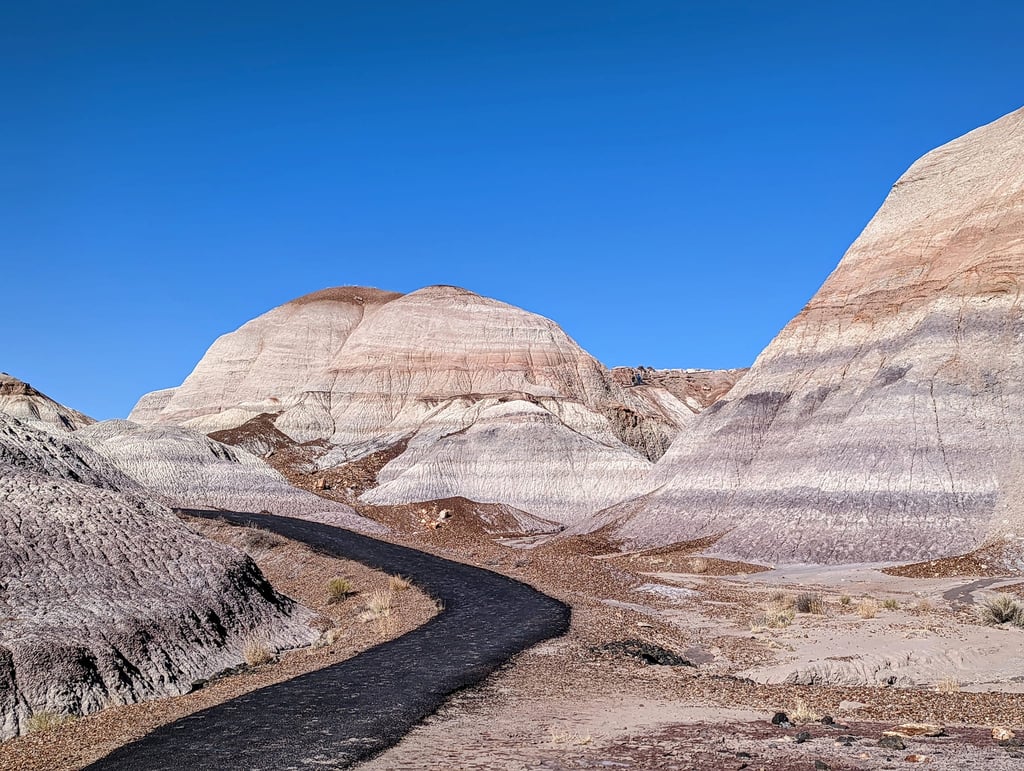
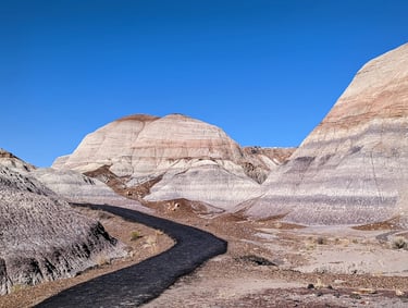
The Painted Desert of Petrified Forest National Park in Arizona, USA
When we were travelling through USA back in 2022, I was planning our stops armed with my geology guide for Arizona and one of the stops on the itinerary was Petrified Forest National Park. I didn't really expect much, but the park actually ended up blowing my mind and it was one of our favourite stops during our Southwest USA roadtrip. The Painted Desert is famous for its vibrant, multi-colored landscapes, composed of rolling badlands, mesas, and eroded rock formations. The striking hues of red, orange, pink, purple, and gray come from layers of Triassic-era sedimentary rocks and ancient volcanic ash, which have been shaped by millions of years of erosion. These colors change throughout the day, especially at sunrise and sunset, creating breathtaking scenery.
Aside from the colourful layercake-like hills of the Painted Desert, the name "Petrified Forest" comes from the fact that the park is home to some of the world’s most impressive petrified wood fossils, dating back over 200 million years. The park also contains remnants of ancient Indigenous cultures, including petroglyphs and pueblo ruins from the Ancestral Puebloans. [link to our southwest USA roadtrip blog]

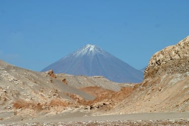
Licancabur Volcano towering over San Pedro de Atacama in Chile
San Pedro de Atacama is one of the most popular tourist destinations in all of Chile and for good reason. The town with its adobe houses, surrounded by desert, salt flats and volcanoes feels like a different world. I've been there twice, once in 2007 and then again in 2010 and will probably be going back as soon as I can. This photo is taken just outside the town of San Pedro back in 2007.
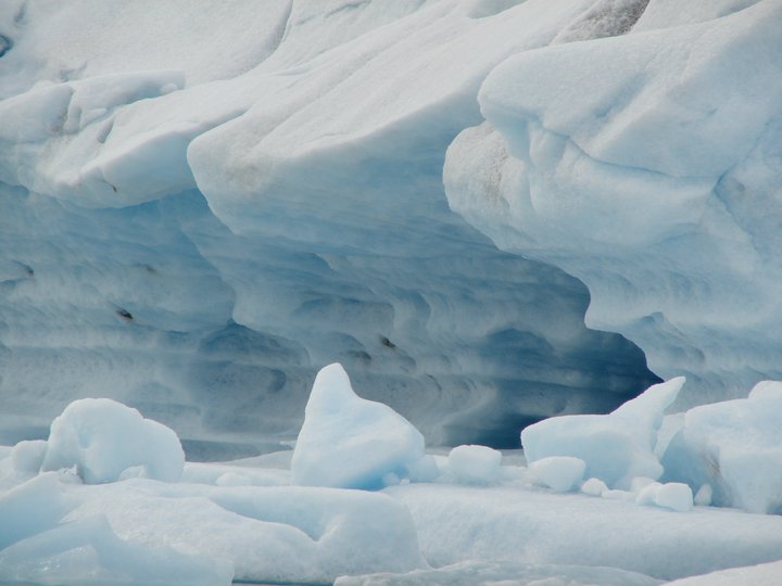
Icebergs floating in Jökulsárlón in southeast Iceland
One of my favourite stops along Route 1 in Iceland is stopping at the glacier lagoon Jökulsárlón. When I took this picture, the weather was completely still, turning the lake into a perfect mirror, so you'll struggle telling what's an iceberg and what's a relflection of an iceberg.

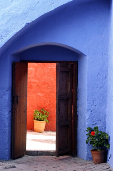
Santa Catalina Monastery in Arequipa, Peru
I was in Peru back in 2007 and stopped by in Arequipa. There, they have this monastery which is absolutely one of the most photogenic places I have been. Morocco has similar sort of places, like Chefchouen's blue colours, Marrakech's orangish colours and Fes' white colours. However, Santa Catalina mixes all the different colours to create these playful contrasts that are just a photographer's dream.
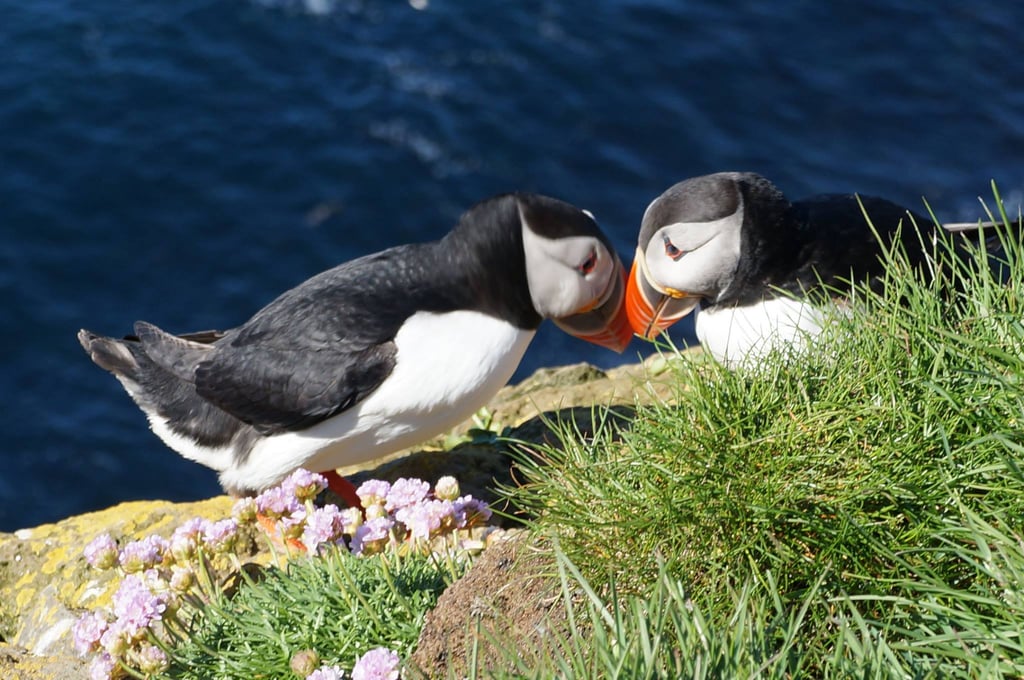

Billing Puffins in Latrabjarg, Westfjords of Iceland
My and Joe went on an impromptu trip to the Westfjords one day when the weather forecast was good. One of the places we stopped at is a bird watcher's spot called Látrabjarg, which is frequented by puffins in the spring and summer. The puffins are really docile and don't care the slightest about humans wandering around, they just keep going on with their business. I was lucky to catch this photo of two puffins billing. "Billing" in puffin terms refers to their charming courtship behavior where pairs rub and tap their brightly colored beaks together, similar to nose-rubbing, to strengthen their lifelong pair bond and greet each other, a ritual often accompanied by head-bobbing. This affectionate display is a key part of their mating process, showing how they say "I love you" and bond as mates, and can even involve interactions with neighbors.
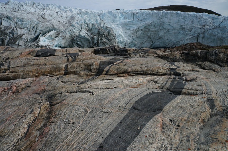

Russell Glacier near Kangerlussuaq, western Greenland
In the summer of 2016, while I was in Iceland finishing my BSc in geology, I came across an offer from Air Iceland that was too good to pass up. They were advertising an introductory return flight to Kangerlussuaq on the west coast of Greenland, including checked luggage, three nights’ accommodation and breakfast, all for a bargain £320 per person. I had never been to Greenland, and it doesn’t get much cheaper than that, so Joe and I jumped at the chance and went.
While we were there, we booked a tour with a company called Albatros Arctic Circle, which runs day tours using enormous monster trucks fitted with huge wheels designed to handle the rough glacial terrain. The tour was incredible - if you ever get the chance to go, I highly recommend it. The glacier itself is spectacular, but even more striking are the rocks, beautifully polished by glacial erosion. These exposures reveal sedimentary- and igneous-derived gneisses that form part of the Archaean (4.0–2.5 billion years old) and Palaeoproterozoic (2.5–1.6 billion years old) bedrock of western Greenland. These rocks were intensely folded around 1.9–1.8 billion years ago during the collision of two fragments of a previously rifted, large Archaean continent. This event led to the deformation and mixing of the "younger" Palaeoproterozoic rocks.
The Kangerlussuaq region has truly spectacular geology and is particularly notable in that it hosts around two-thirds of all known diamond-bearing rocks in Greenland.

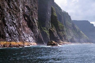
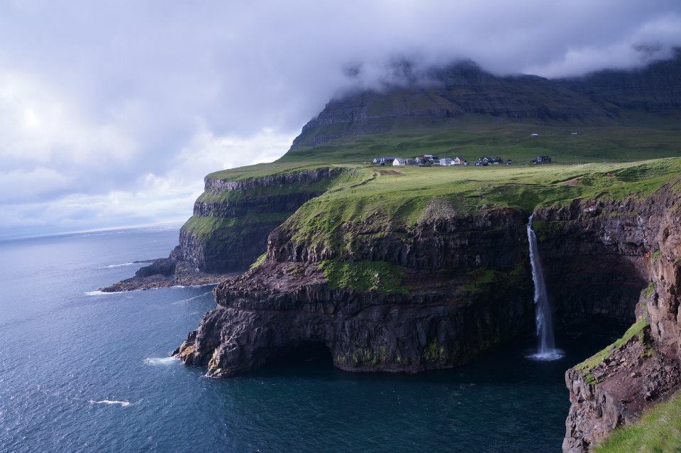
Vestmanna Cliffs of the Faroe Islands
Me and Joe travelled to the Faroe Islands back in 2015. I had gone back to Iceland after my year of Erasmus exchange in Glasgow while Joe stayed in Glasgow. Rather than him always travelling to Iceland to see me, or me travelling to Scotland to see him, we met in the middle at one point - in the Faroe Islands. Atlantic Airways fly from both Edinburgh and Iceland (from Reykjavik airport then, but nowadays I believe they fly from Keflavik).
I had a real hard time trying to decide on a single photo from our boat tour along the cliffs of Vestmanna in the Faroe Islands. I just remember being completely awe-struck during the whole tour, the cliffs and the rock formations are just so incredibly dramatic. Sailing along these cliffs just transports you to what feels like a different world.
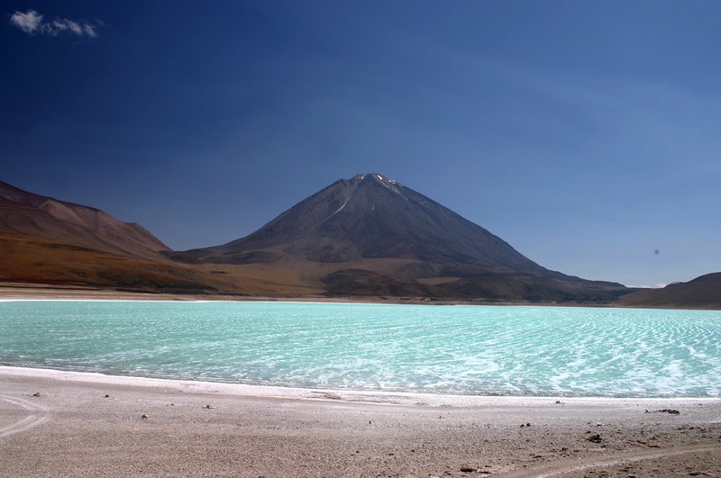

Laguna Verde in the Bolivian Altiplano and Licancabur volcano in the background
There are so many incredibly vistas all around the Bolivian altiplano in the southwestern corner of the country, but this one always sticks in my mind as one of the more memorable ones. The beautiful light blueish green Laguna Verde lake with the towering Volcan Licancabur in the background, but the volcano straddles the border of Chile and Bolivia.
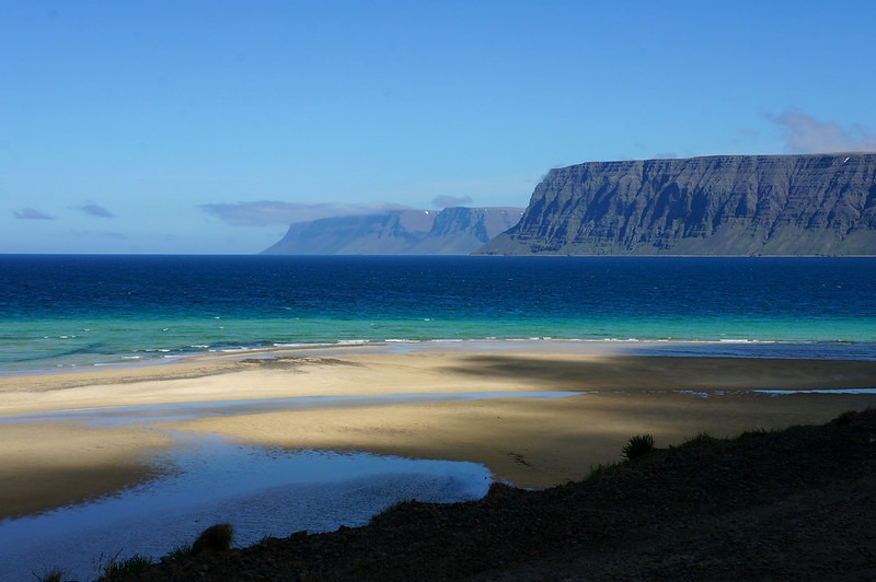
Patreksfjörður in the Westfjords of Iceland
We were so incredibly lucky with the weather the one time in my life I've been to the Westfjords of Iceland. This photo was taken on our way from Látrabjarg Cliffs on our way along the fjord of Patreksfjörður. The Westfjords of Iceland is one of the few places in Iceland where you actually have white sand beaches, and with the right light conditions, the sand, sea and surrounding mountains just look utterly stunning.

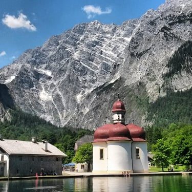
Königssee near Berchtesgaden in Bavaria, southern Germany
I travelled to Munich in southern Germany in 2014 to attend the Rock im Park rock festival in Nuremberg but I had some time to explore southern Germany before the festival started. When looking into where to go, I thought I'd go and see what the German Alps were like. I went to Berchtesgaden, which is so very scenic. Near the town, there´s the lake of Königssee, and I was just blown away by how beautiful the scenery was, and how dramatic the mountains were, rising almost straight up from the ground, surrounding the lake.
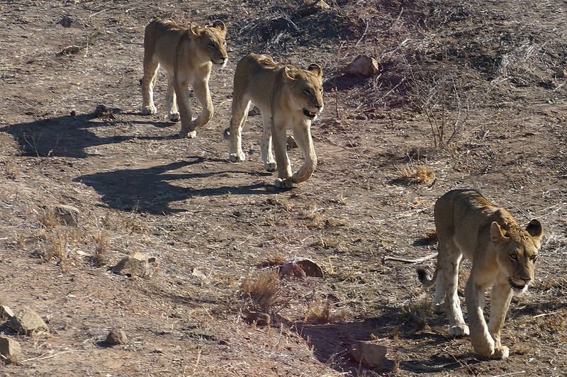
Lions in Kruger National Park in South Africa
This is another place I've been to that stands out as one of the most incredible places I have ever been to in my life. As a place to see wildlife in Africa, Kruger National Park is so well maintained, they don't rip you off and there's such an incredible abundance of wildlife here that you are more likely to see a giraffe or a rhino here than sheep in Scotland, I kid you not!! I was there in the month of September 2016 and saw just about every type of animal you'd ever imagine seeing on a safari in Africa; lions, rhinos, giraffes, elephants, buffalo, hyenas, leopard, impalas, kudus, wildebeest, crocodiles, hippos, zebras, baboons, warhogs, you name it! So with such incredible sightings, you can imagine it's hard to pick a favourite photo from a favourite place. I quite like this photo due to how close the lions came to our bus.
Honestly, if you ever wanted to go on a safari, go to Kruger. It is not expensive, it is easy to self-drive and honestly, it is just so amazing. I will never forget it.
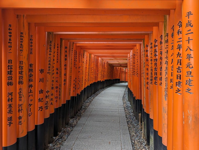

The tori gates of Fushimi Inari Taisha in Kyoto, Japan
Fushimi Inari Taisha is one of Kyoto’s most iconic and atmospheric Shinto shrines, famous for its seemingly endless pathways of thousands of vermilion torii gates that wind up the forested slopes of Mount Inari. Dedicated to Inari, the Shinto deity of rice, prosperity, and business success, the shrine dates back to 711 CE and serves as the head shrine of more than 30,000 Inari shrines across Japan. The torii gates, donated by individuals and companies seeking good fortune, create a striking tunnel-like corridor that changes character as it climbs higher into the quiet, wooded hills. The place is incredibly popular with tourists, but for those who are willing to walk through more gates further up Mount Inari, you get awarded with much more peaceful experience of the shrine, as pictured above. [link to our Japan blog]

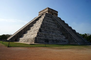
Temple of Kukulcán at Chichén Itzá, Yucatan Peninsula in Mexico
I have been to a fair few epic ancient monuments throughout my travels, including Teotihuacan near Mexico City, Tikal near Flores in northern Guatemala, Machu Picchu in Peru, Angkor Wat in Cambodia and the Pyramids of Giza. The famous Temple of Kukulcán was always going to be a challenge to get a good picture of, because Chichén Itzá is wildly popular and there isn't much in the way of crowd control there. However, as we were self-driving the Yucatan Peninsula, we could make sure we were there right at the moment the site opened, arriving ahead of all the tour buses. That meant I was able to get this snapshot of the most important, impressive and popular pyramid of all the Americas without a single person in the photo!
By the time all the cruise ship passengers and Cancun All Inclusive resort tourists arrived on tour buses, we had already explored the full site in relative peace and quiet, with the hustling vendors only just starting to show up when we were maybe half way through our touring of Chichén Itzá. We then headed to the restaurant at the archaeological site and had the best breakfast we possibly ever had - Huevos Motuleños, which they make particularly well at this restaurant back when we were there in 2017.
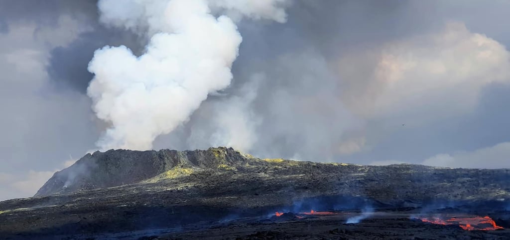
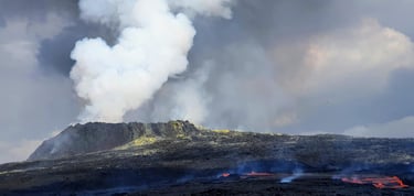
Fagradalsfjall 2021 volcanic eruption in Reykjanes Peninsula, Iceland
Me and Joe travelled with Joe's dad and his wife to Iceland in 2021 and were fortunate enough to be there at the very same time as a volcanic eruption was on-going in the Reykjanes Peninsula, a stone's throw from Keflavik International Airport. However, there had been some bad weather and poor visibility, so it wasn't certain whether we'd actually get a chance to see it or not. The eruption took place in an area that was fairly easy to access, and unlike the more recent eruptions in this volcanic fissure system, there were not many fissures that had formed, so public access was allowed literally right up to the flowing lava. I can't even put in words the feeling as we approached the eruption site from the top of the hill, descending towards the lava, with the thundering noise as the crater spewed out fresh lava and volcanic gases. It was literally a once in a lifetime experience and we were so glad Paul and Jean could come with us on their first ever trip to Iceland and get to experience something so incredible.
Múlafossur Waterfall in Gásadalur, Faroe Islands
When we travelled to the Faroe Islands back in 2015, we rented a car from the airport in Vágar and drove around the island. Driving around is incredibly scenic in general, but there are specific places that are just that one bit more special, like this waterfall that falls off a cliff straight into the sea in the village of Gásadalur. To get there, we needed to go through a slightly scary dark single track tunnel, but rewarded with spectacular views on the other side!

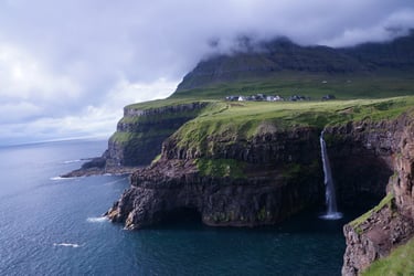
Redstone Hills on the road from Route R62 to Swartberg Pass in South Africa
This picture brings up a lot of memories from my 2016 trip to South Africa. I went to the International Geological Congress, as well as on a congress excursion, but I also went on a roadtrip on my own from Cape Town airport through Route 62 that took me through some of the most spectactular landscape South Africa has to offer. I turned off R62 to drive across the (what I later learned infamous) Swartberg Pass. As you drive through the landscape, you see these really peculiar looking, reddish hills and mounds. On further inspection, they turned out to be conglomerates, which I thought was really interesting. This area is also full of wildlife, which was totally unexpected but I saw lots of impalas, kudus, ostriches and turtles while I was driving through there.
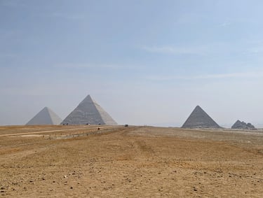
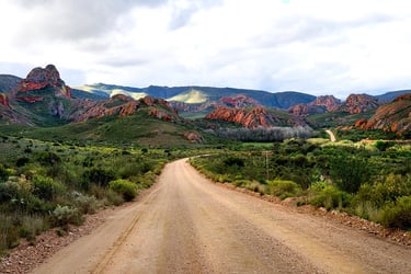
Pyramids of Giza in Egypt
This photo is definitely not the best photo you'll ever have seen of the Pyramids of Giza. My ambition to get the perfect shot from the perfect location pointing towards the perfect angle kind if went out the window as the temperature increased on the Giza Plateau. However, I have really fond memories of the pyramids. So many people I have spoken to tell me how much they hated Egypt, that it was so crowded and there were so many hustlers and really agressive vendors everywhere, but that wasn't our experience at all! You can barely see a single soul in this photo, and while yes we did get the occasional guy trying to offer us camel rides or whatever, I have experienced much more agressive selling in places like Mexico or Peru, to mention a few places. I think that the key thing to do, which is what we did right in this instance, is to stay at a hotel in Giza and just leave as early in the morning as you possibly can. This way you avoid the crowds, the more agressive vendors and the heat. [link to our Egypt blog]
Háifoss waterfall in the southern highlands of Iceland
As I mentioned earlier, there are so many waterfalls in Iceland that you can fill a big book full of pictures from them. However, Háifoss holds a special place for me, and this particular photo from the waterfall holds a special memory as well. The road up to the falls is quite treacherous and you need a 4WD to get up the hill. We were there on this occasion with Joe's dad and his wife, but unfortunately arrived in the middle of the clouds with zero visibility. The weather wasn't looking good. However, we persevered a little bit longer, and a few moments later, the clouds started to disappear, with such spectacularly dramatic effects. It was just beautiful.
The waterfall is absolutely massive, but if you look at the top-right of the picture, you see a couple of people standing at the top of the hill, for scale.
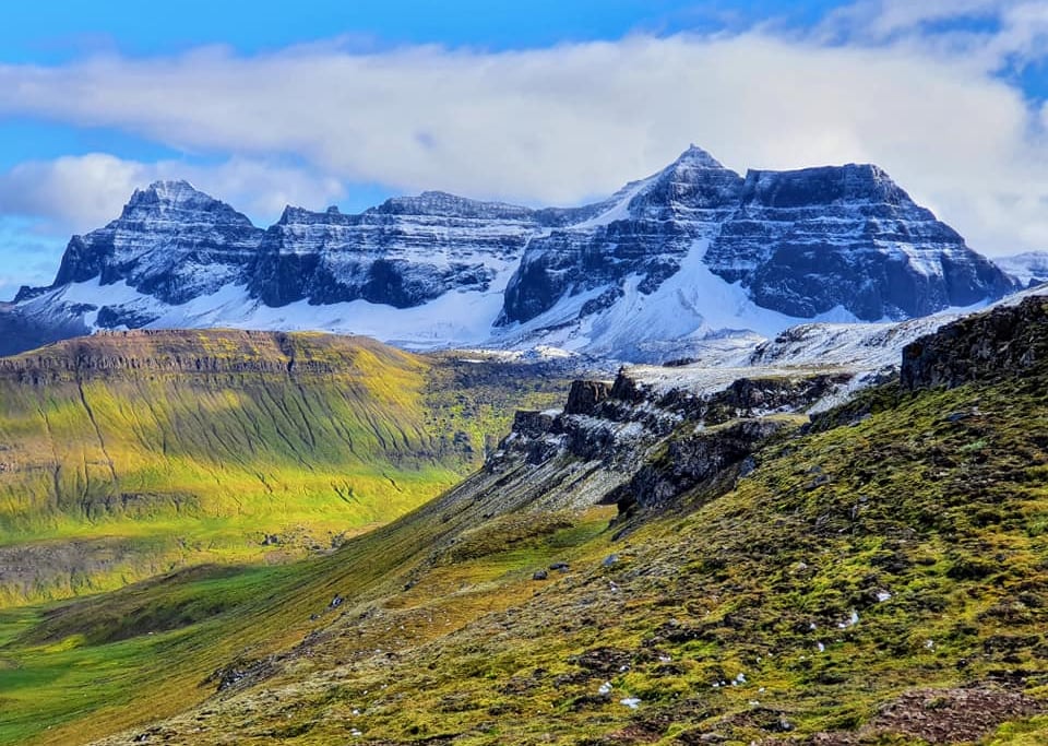
The mountains surrounding Borgarfjörður Road in the Eastfjords of Iceland
I know this article will be quite biased towards Iceland, as I am from there and I have spent more time travelling there than anywhere else. But Iceland also does have some ridiculously amazing scenery. This is one of my favourite shots, but me and Joe went to Iceland at the first sign of COVID19 lockdown relaxing a bit in 2020. We did our quarantine in a summerhouse in the countryside and once that was over, we rented a campervan and travelled around the whole island. This particular photograph is from the Eastfjords, but I had never been to the region of Borgarfjörður Eystri and this mountain scene just blew my mind. [link to our Iceland Roadtrip blog]
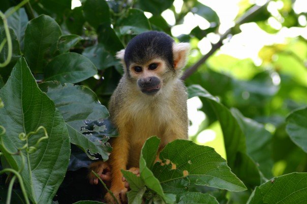
Black-capped squirrel monkey near Rurrenabaque in Bolivia
I took this photo when I was on a Pampas tour in Bolivia back in 2007. The Pampas Tour starts in a village called Rurrenabaque in the Bolivian Amazon and it takes you, over the course of 3 days, through the wetlands of the rainforest where you see an incredible amount of wildlife. We travelled by a boat and approached a tree next to the riverbank, when a horde of monkeys came jumping through the trees towards us, which is when I managed to capture the photo of this wee fella. Aside from loads of monkeys, we also saw capibaras, sloths, pink river dolphins, turtles, cayman crocodiles, piranhas, tarantulas and anaconda. It is one of the absolutely best places in South America to see wildlife. In Rurrenabaque, they also do a different tour called the "Jungle Tour" and that one is land-based focussing primarily on jungle survival skills and learning about plants, like medicinal plants, poisonous plants, plants used for hunting, plants used as a water source, edible plants and so on.
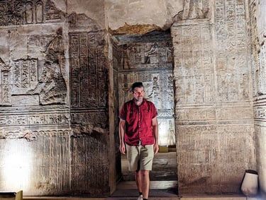
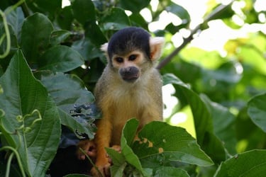
Temple of Hathor or Dendera Temple in Qena, Egypt
I took loads of pictures that I'm really happy with at the Temple of Hathor (Dendera Temple) in Qena near Luxor in Egypt, however while this photo is perhaps not the most "typical" image you see from the temple, I really liked the action shot of Joe as he was coming out of one of the many nooks and crannies this wonderful ancient temple has. We had by this point spent over a week in Egypt and done the River Nile cruise but went independently to this temple not far from Luxor, hiring a taxi to drive us there, wait for us and take us back to Luxor. This temple, while it doesn't look like much on the outside, is absolutely incredible on the inside. The intricate details of the carvings in every single passageway and every single room, rooms that have big towering walls, and the impressively decorated and massive columns that decorate the main halls, it was just so incredible. The entrance fee is an absolute bargain and we had this temple practically to outselves. I so absolutely 100% recommend you put the effort in to visit this incredible place if you're ever in Luxor in Egypt. Wow just wow. [link to our Egypt blog]
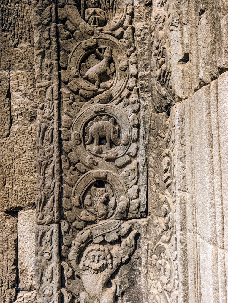
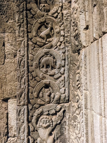
An apparent stegosaur at Ta Prohm temple in Angkor Archaeological Park near Siem Reap, Cambodia
The relief appears on a pilaster (upright support) of a doorway in Gopura III. This small, hand-sized bas-relief shows a squat, four-legged creature with a row of raised shapes along its back that some modern viewers liken to the plates of a stegosaur dinosaur. However, most archaeologists interpret it as a stylised local animal (such as a rhinoceros or other creature) with decorative foliage or artistic conventions of the Khmer period, rather than a literal dinosaur depiction. Though one has to wonder about the things like the Chinese legends of dragons - would the ancient people have come across fossils, from which they made up these mythological creatures? [link to our Southeast Asia blog]
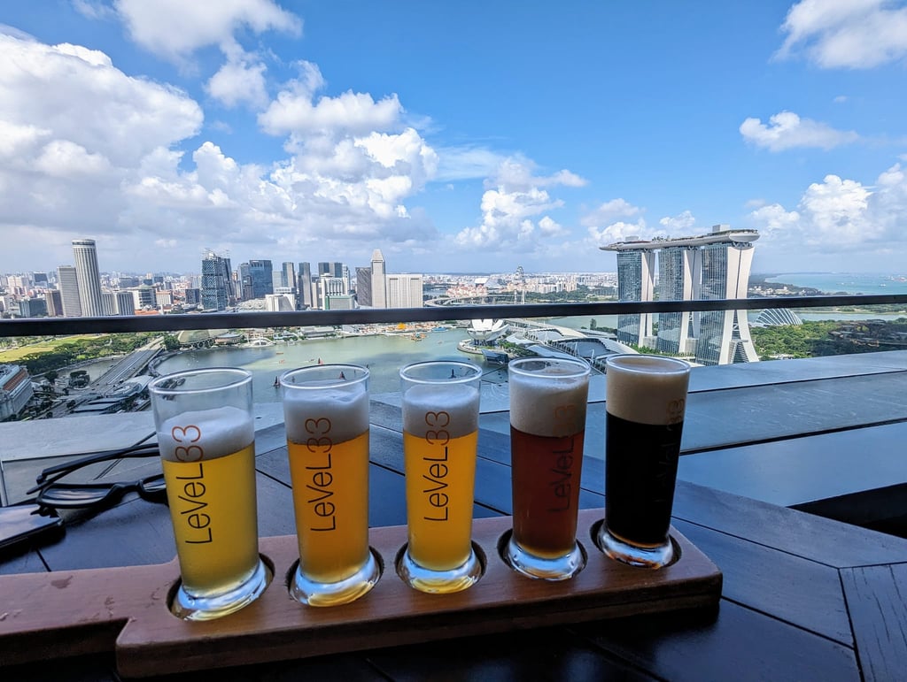

A flight of craftbeer at the LeVeL 33 microbrewery in Singapore
We discovered this microbrewery by absolute chance when we were in Singapore back in 2024. We had gone to this nice restaurant in town, and in the same building there was meant to be a rooftop bar we meant to go to for some views of the city. However, the bar was closed so I had to search for an alternative. Thanks to Google Maps, we spotted this place, which turned out to be way better than our first option, with absolutely incredible view over the bay in Singapore, including the Marina Bay Sands building and Gardens by the Bay. We were extremely lucky to get a seat with a view as walk-ins, I would suggest booking a table if you plan to go. [link to our Southeast Asia blog]
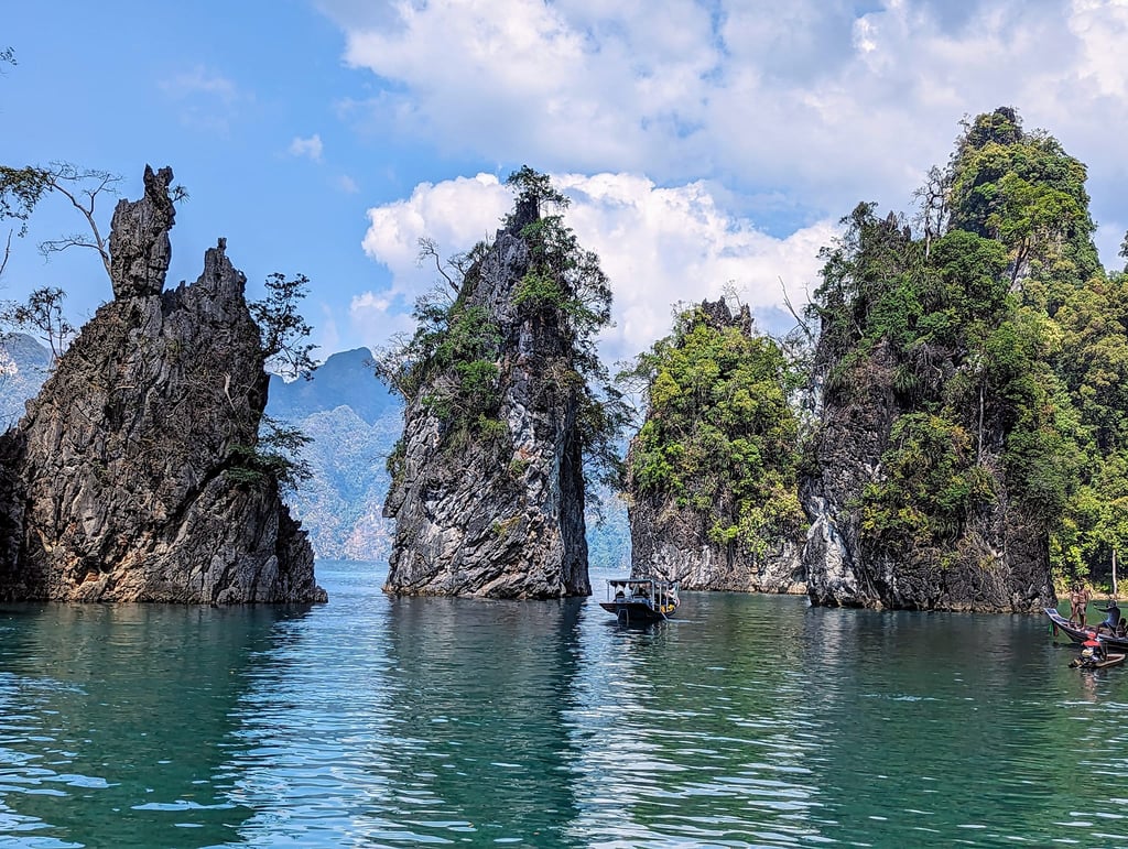

Khao Sok National Park in southern Thailand
We travelled from Koh Lanta to Khao Sok village near Krabi back in 2024 and went on a 2-day tour of Khao Sok National Park. Its spectacular scenery makes it one of Southeast Asia’s most geologically striking national parks. It is dominated by dramatic towering limestone karst landscapes that are among the oldest in the world. The park’s limestone formed during the Permian period (roughly 300–250 million years ago), when the region lay beneath a warm, shallow tropical sea. Over millions of years, thick accumulations of marine sediments, rich in shells and skeletal material, were compacted and lithified into limestone. Later tectonic uplift exposed these rocks, and prolonged chemical weathering in a humid tropical climate dissolved the limestone along fractures and bedding planes, producing the steep cliffs, pinnacles, caves, sinkholes and enclosed valleys characteristic of karst terrain. Extensive cave systems within the limestone host stalactites, stalagmites, and underground rivers, while surface drainage is limited because water rapidly infiltrates the karst. [link to our Southeast Asia blog]

Hengifoss in the East of Iceland
I had seen pictures of this waterfall many many times and always wanted to visit it, but it is quite a bit out of the way, even when you're travelling the full ring road of Iceland. When we went to Iceland with a campervan back in 2020, I made it my mission to see this place. It's a fair bit of a hike to the waterfall, but there are a couple of other just as scenic waterfalls on the way there. This place is like a geologist's dream. Like a textbook "What the geologist sees vs normal people" type of place, though it's difficult to capture all of the different elements clearly in a single picture. What is most obvious in the above photograph I took are the numerous basalt lava flows (the black rock) that are about 5-6 million years old, interbedded with these regular red horizons which consists of palaeosol (ancient soil). The layered succession at Hengifoss essentially records multiple cycles of volcanic eruption and quiet intervals when weathering and soil formation occurred, giving a valuable geological record of changing surface conditions during early stages of Iceland’s formation, [link to our Iceland Roadtrip blog]
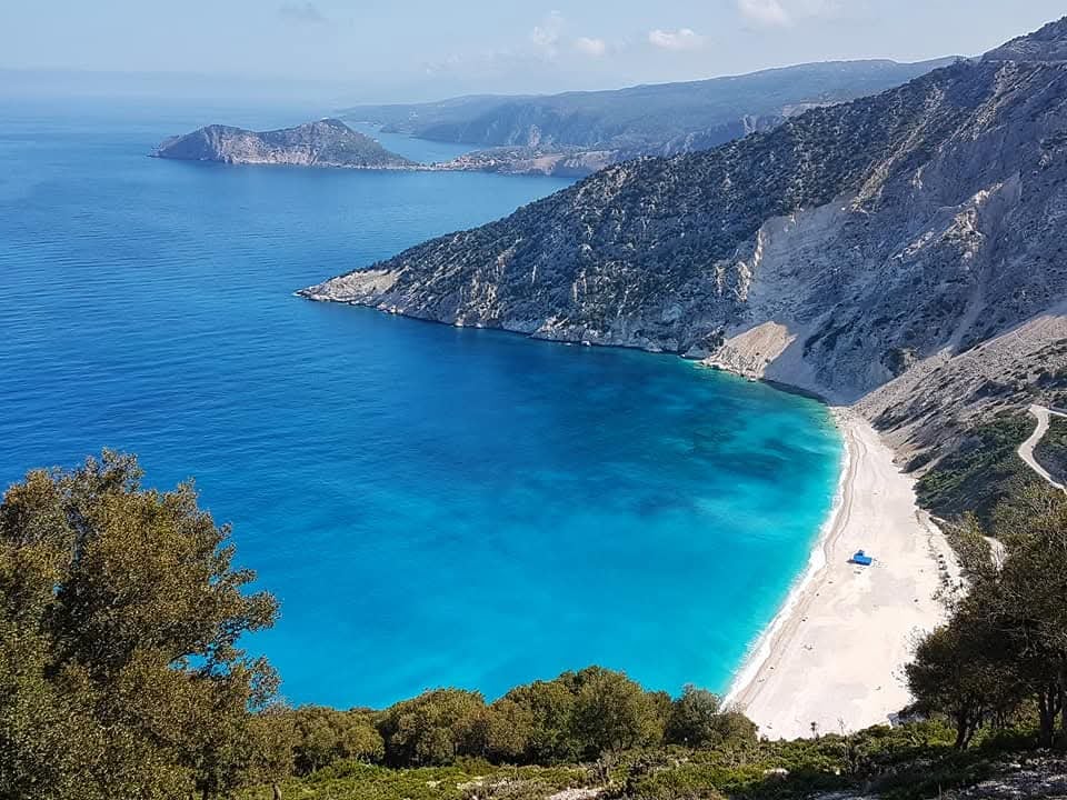

Myrtos beach on Kefalonia island, western Greece
We struck luck with an outrageously cheap 1 week holiday to Greece back in 2018 where we got return flights, luggage and a hotel stay for just £315 per person for the first departure of the year. It was plenty warm and the weather was gorgeous. We also rented a car, which was cheap as chips, and used it to travel all over this beautiful island. One of the most memorable scenic points was Myrtos beach, shown above.
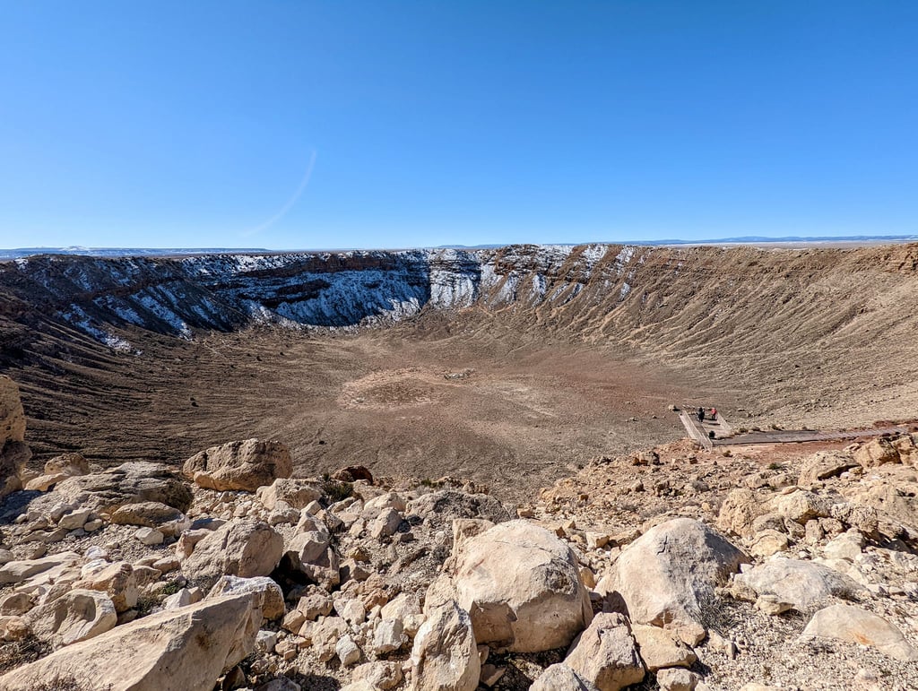

Meteor Crater, Arizona
Meteor Crater, also known as Barringer Crater, is a well-preserved impact crater located in northern Arizona, about 55 km east of Flagstaff. It formed approximately 50,000 years ago when a nickel-iron meteorite, roughly 30–50 metres across, struck at high velocity. The crater is about 1.2 km in diameter, 170 m deep. Meteor Crater is scientifically important as the first site conclusively identified as an impact crater on Earth and remains one of the best examples for studying impact processes and shock metamorphism. The crater can be easily seen on satellite imagery on Google Maps, where the size and shape can be better appreciated compared to "on-the-ground" photos. [link to our Southwest USA roadtrip blog]
Follow us on Social Media for travel updates and top tips!
© 2026. All rights reserved.
I can't recommend Pimsleur enough for learning a new language! If you don't believe me, try for your self - All Access FREE for 7 days on signup.