Geological Case Study: Coalsnaughton, Clackmannshire
The evacuations in the former mining village of Coalsnaughton, Clackmannanshire, officially began on Monday, May 18, 2026. The evacuations happened in phases as officials discovered escalating evidence of ground movement and structurally unsafe buildings. The initial 30 homes on Benbuck View were evacuated on May 18th, followed by a further 30 properties on May 27th on the adjacent Dunmoss View. On May 29, an additional 28 homes on Nechtan Drive and 9 homes in Lagour were cleared out as a precaution, bringing the total to nearly 100 displaced households. This story obviously peaked my interst as a geologist, so here goes a little geological case study of the area.
GEOLOGY
6/4/202614 min read
I am an engineering geologist by trade but one of my hobbies is research into the mining history of places of interest. This blog, which is fairly new, will contain several case studies that I am working on, such as the story of the Anglesey Coalfield, which most people don't even know exists, and the mining history of Robroyston in the suburbs of Glasgow and likely several others (send in your request if you want me to have a look at anything specific and I'll see if I think it's a worthwhile case study). My interest was peaked when I learned about the evacuations of people from their homes in the village of Coalsnaughton in Clackmannanshire in May 2026, so I thought I'd have a look at what might have been going on there, but the village has a long history of coal mining, with more industrial scale coal mining starting in the early 1800s. DISCLAIMER: This article is only intended for educational purposes ONLY and not to be reproduced or relied upon by professional mining engineers.
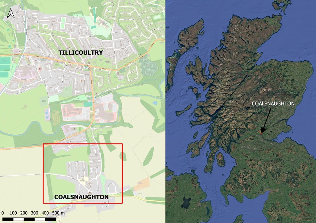
Just to set the scene, let's show you where Coalsnaughton is located in Scotland:

Geological Setting
To start with, let's set the geological scene. The village of Coalsnaughton sits on Glacial Till from the last ice age (so typically clay with sand, gravel, cobbles and boulders), but the residential estate that was evaculated is bounded by two streams, which according to geological maps, apparently cut through the till and into bedrock. To the north of Alexandra Street, Tidal Flat deposits consisting of silt and clay are mapped.
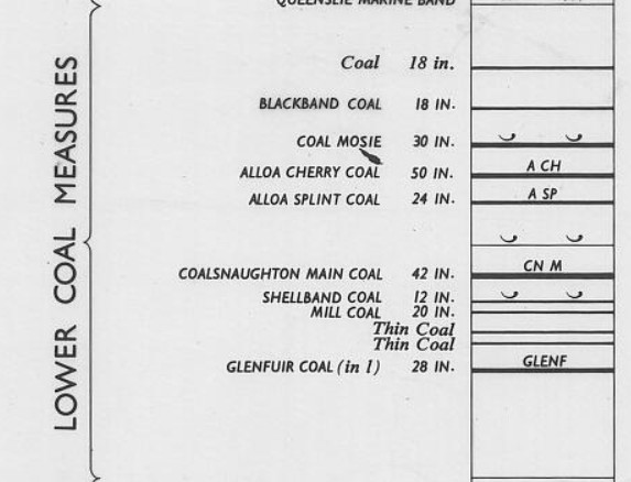
The bedrock falls under Scottish Lower Coal Measures and there are numerous coal seams that underlie the village. You can see the generalised vertical section of the Lower Coal Measures in the image below, but as we will see as you move down this article that we know that Coal Mosie, Alloa Cherry Coal and Alloa Splint Coal outcrop within the village, i.e. those coal seams are right beneath the ice age sediments. The Coalsnaughton Main Coal also outcrops not far from the residential estate, just a few meters north.
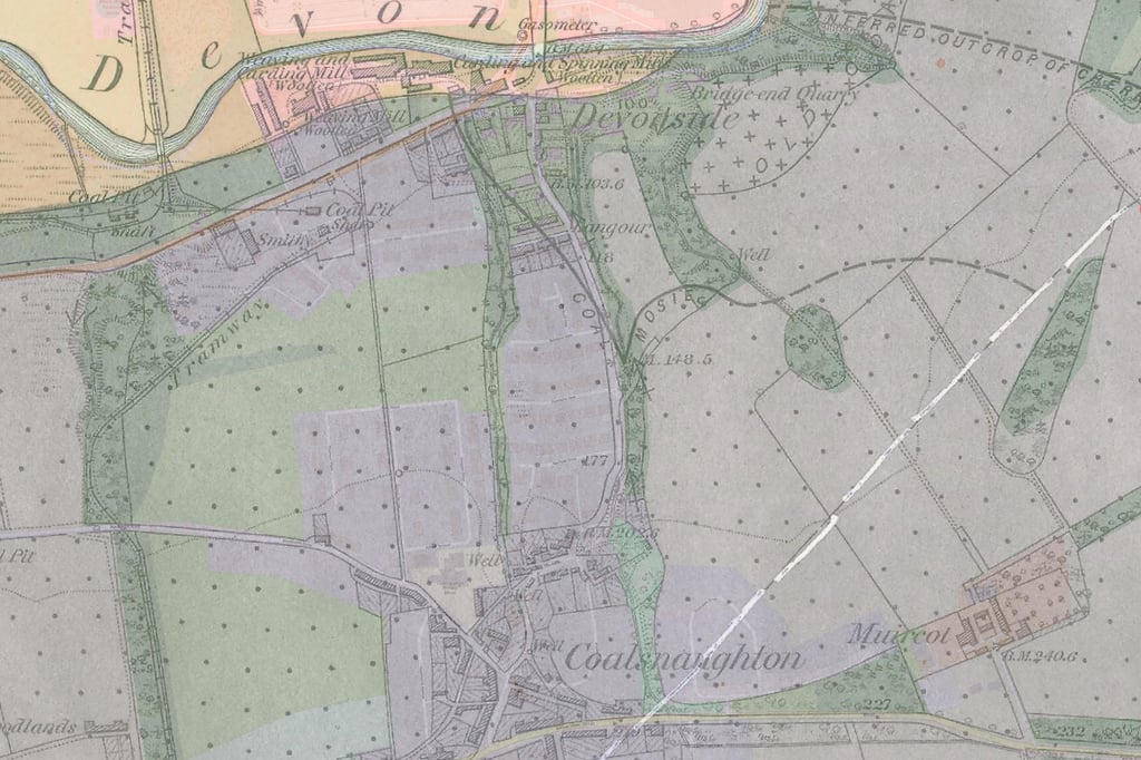
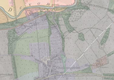
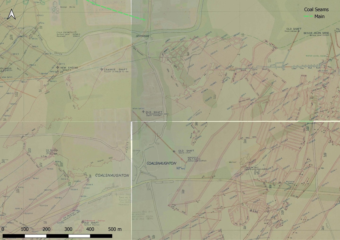
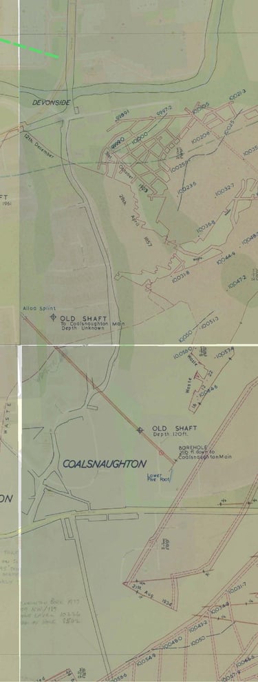
County Series geological map of Coalsnaughton dated 1878 . Source: BGS Mapping Portal.
Where you often find more detail is on the more modern National Grid 1:10,000 series NS99NW sheet geological map from 1964, from which I showed you the generalised vertical section above.

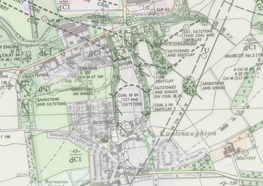
BGS National Grid Series geological map of Coalsnaughton from 1964. Source: BGS Mapping Portal.
On this map we can see that they've recorded 4 different coal seams in the stream east of The Glen; 0.15m Coal and a 0.25-0.46m coal which is unnamed but shown in the same location as the Coal Mosie on the County Series map. However, on the geological vertical section, the Coal Mosie is shown as 0.76m thick. Looking north, the next coal is the Cherry Coal with a thickness of 1.27m, which according to the vertical section sits beneath the Coal Mosie, followed by the underlying Splint Coal 0.61m in thickness.
On this map, there are also a few additional shafts compared to the County Series, marked with a circle with a cross through it, as well as adits where there were portals for tunnels going into the mines. If you now put your geological hat on, and do some trig of the elevation where the Splint seam outcrops and take your dip angle , once at Benbuck View, you'll find yourself some 5 to 24m higher up in the rock, so at 32.9-51.9mAOD, depending on whether you believe the County Series dip magnitude (gently dipping near horizontal) or the National Grid Series (5 degrees). The ground elevation at Benbuck View is 45.8mAOD, but I know that the National Grid series are exaggerating the dip magnitude, because mine plans exist showing the Splint coal mined beneath the entire residential estate, as you will see further down.
The National Grid Series map suggests a slightly more north-westerly dip direction compared to the Count Series, and gives a dip magnitude of 5 degrees. Now, normally you'd look at the position of the coal seams and note in what order they appear. If they were dipping to the north or northwest, you'd typically expect the older seam (lower down in the stratigraphic column) to outcrop furthest to the southeast. However, here that is not the case and the reason being that there's a fair bit of natural gradient towards River Devon. This is why we see the highest seam in the south. The seams are located at the following elevations where they outcrop in the stream:
6" seam is at 55.8mAOD,
Coal Mosie at 49.5mAOD,
Cherry at 36.2mAOD; and finally
Splint at approximately 27.9mAOD.
Taking into consideration the dip angle and dip direction, the elevation of the coal seams rises as you go southeast, though so does the natural terrain, whose gradient is about 4.7 degrees.
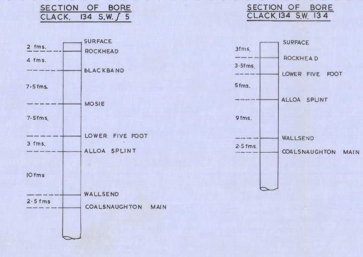
There is a mine plan that shows the distances between each of the seams:
Mosie Coal to Cherry (Lower Five Foot) 7.5 fathoms (13.7m),
Cherry/Lower Five Foot to Splint 3 fathoms (5.5m) and
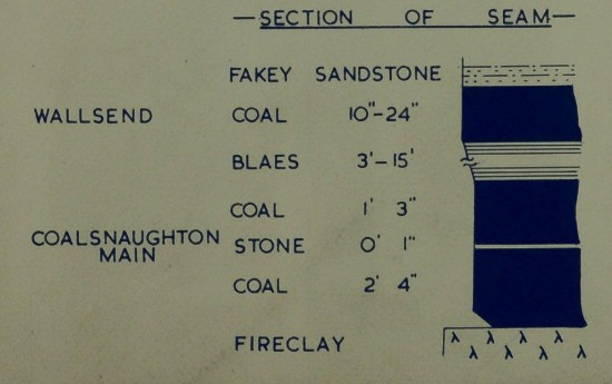
Splint to Coalsnaughton Main 12.5 fathoms (22.9m) - though it's 18m from Splint to Wallsend, which was often extracted alongside the Main.

Snippet of the generalised vertical section from BGS 10k geological map NS99NW showing bedrock beneath Coalsnaughton.
Here you can see that the Coal Mosie is 0.79m in thickness, the Cherry Coal is 1.27m, Splint Coal is 0.61m and the Coalsnaughton Main Coal is 1.07m in thickness. However, thicknesses of the individual coals will vary regionally. Seeing as these outcrop within the residential estate, it is safe to say that any mineworkings in these seams would be very shallow.
When I look into the mining history of a place, I tend to trust the older geological maps better. Much of the reason why so much money and time was spent on mapping the geology back then was for the record of economic minerals. Therefore, it's safe to assume they wanted to keep good records of where these economic seams were to be found.
The County Series geological map from 1878 shows the Coal Mosie to outcrop in the stream that runs along The Glen in Coalsnaughton immediately to the east of the village. The symbology on the map shows the strata to dip very gently, near horizontal, in a northerly direction. The map also shows us the location of a couple of coal pits in the vicinity of the village - one between modern day Ochil View and Bain Street, the other near The Devon Way as it turns away from Alexandra Street towards the River Devon.
A snippet from the 1878 map is shown below, overlying a modern OpenStreetMap layer.
It is known from mine plans that the Splint seam has been worked extensively, possibly completely exhausted in this area, with the exception of pillars that may have been left. The Coalsnaughton Main has also been extensively mined, often along with the Wallsend at the same time. There is little evidence to suggest that the Cherry/Lower Five Foot or Mosie have been extracted, but given the fact that they are of workable thickness (usually seams that are 0.3m in thickness or more), it is not possible to rule out that maybe that seam has been extracted here as well. So you can see there could be a problem if your house is sitting right above the Cherry outcrop, with Splint worked so very shallow below.
Mine workings in the Lower Five Foot Coal
The records for mine workings in the Lower Five Foot coal beneath Coalsnaughton are a bit fuzzy. When you look at the mine plan, it shows workings towards the town however the lines and the shades of pink are just made to fade out, without any definitive end to the workings. When I georeferenced the plans and exported them, I tried to use as little transparency as possible for the area where the pink shaded areas just seem to fade out of nowhere - I have placed red question marks on the plan where this happens, but I am assuming that the seam has been worked in the non-shaded areas too, but probably the workings are just too old to have actual plans of them.
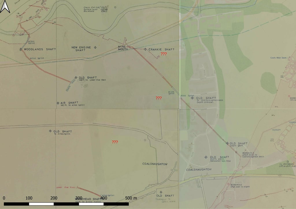
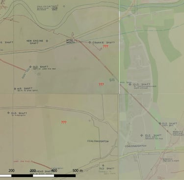
Georeferenced and merged plans of the Lower Five Foot mine workings in Coalsnaughton with reference 26/9095, 26/9096, 26/9295 and 26/9296. (Source: Scotland's People).
The above plans have extracted seam sections on them, which suggest that the thickness of the extracted seam ranged between 40 to 60 inch (1.0-1.5m), with the Splint seam then found some 5.5m below that.
Mine workings in the Splint Coal
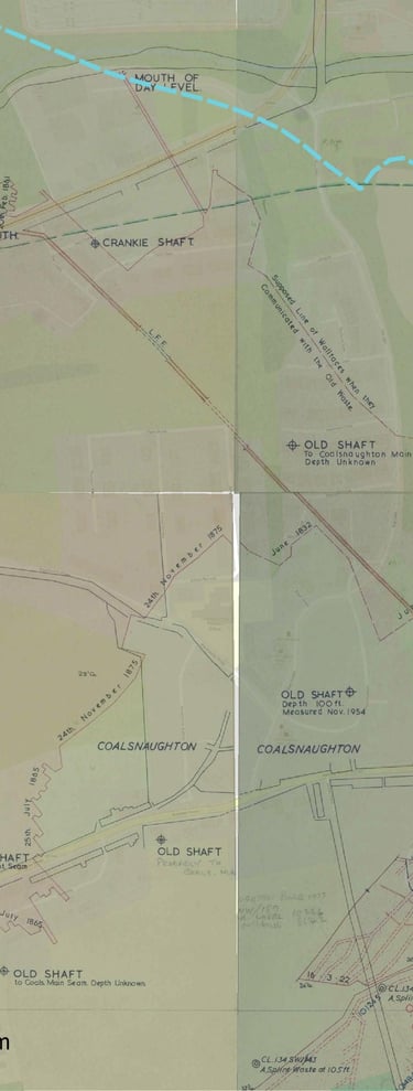
This takes us to the mine plans showing the mine workings in the Splint Coal, which is the shallowest seam in this area known to have been worked. The mining that took place in the early to mid 1800s is shown in blue below. There is a dark blue linear feature where it says "Level" leading from the Split seam outcrop by River Devon. This is an access tunnel to the mine, with the tunnel portal located on the southern banks of the river.
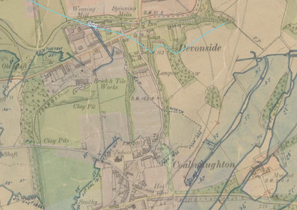
Snippet from mine abandonment plan with modern OS Streetmap below (Source: The Mining Remediation Authority)
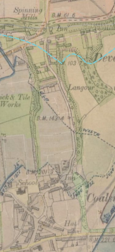
The concerning part here is that just next to the blue coloured mine workings in the Splint Coal within the residential estate, there's a text stating "Old waste", which is where the miners stopped back in 1832 as they encountered ancient workings backfilled with mine waste. The issue with these type of ancient mines is that no record exists of their location, and it is very rare that someone would go at a later date to survey them because they'll be very dangerous and/or inaccessible due to either collapse of the roof of the mine or backfill material. A similar thing is shown on the Coal Board plan of workings in the Splint Coal, which I have georefenced and included below, but you can find the originals on the Scotland's People archives.
Here, the recorded mine workings are shown in red ("unrecorded" are workings such as those shown as "waste" or where the mine workings have not been seen or surveyed). What I have noticed in any news coverage of this incident is that any map showing mine workings does not include this area of ancient mineworkings, when in fact they are present but have just not been surveyed. The BGS recorded location of the Splint seam is shown in light blue. The plan also shows an "Old shaft" with a depth of 120 ft (36.6m) and a borehole that appears to be drilled down in an underground roadway in the Splint stating "21.5 ft down to Coalsnaughton Main", though that seems a bit too short of a vertical distance between Splint and Main. It's known from geological maps that there's a fault in this area that shifts the elevation of the seam, with elevation data available southeast of the fault but none available to the northwest of it.
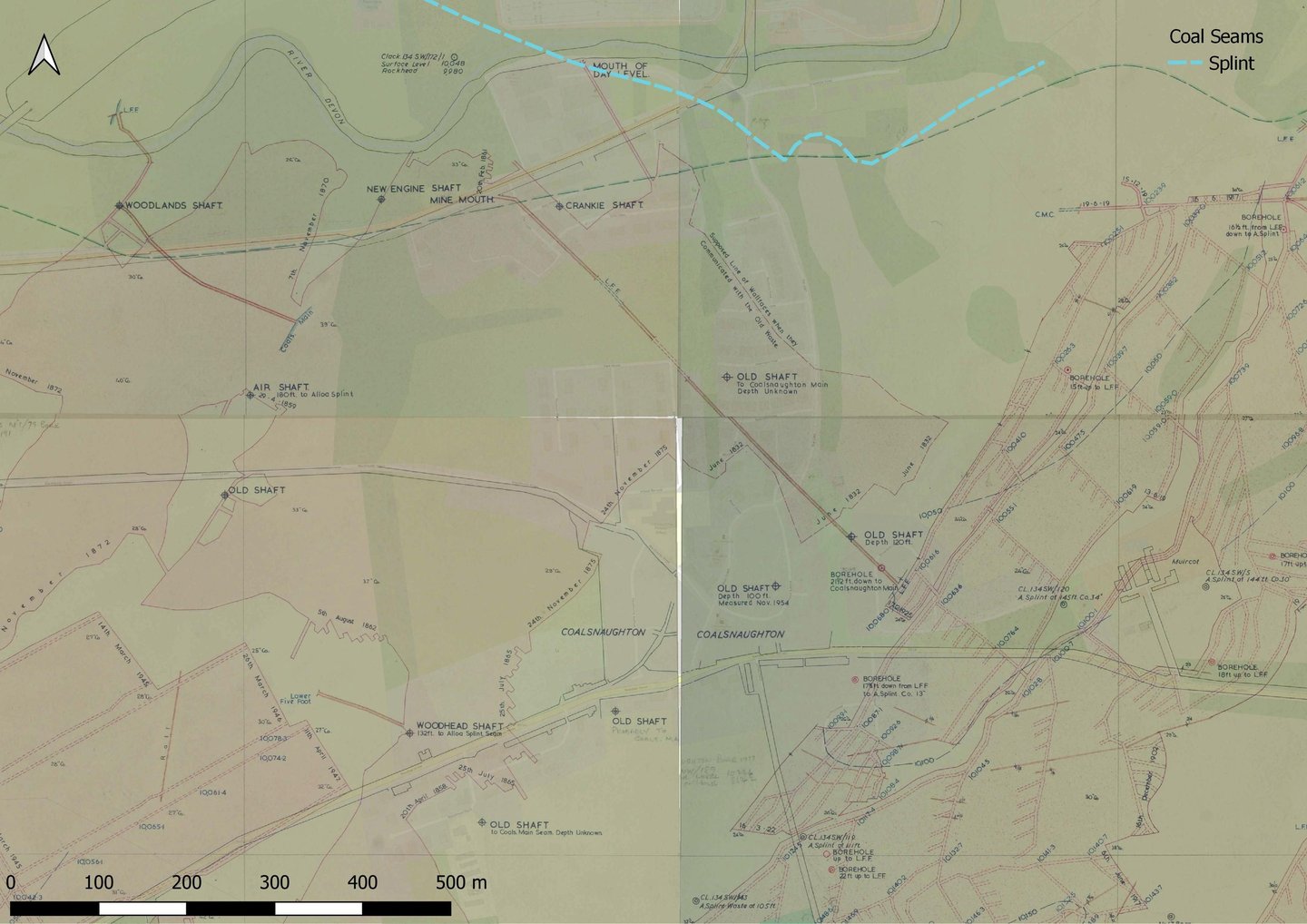
Georeferenced and merged plans of Alloa Splint mine workings in Coalsnaughton with reference 26/9095, 26/9096, 26/9295 and 26/9296. (Source: Scotland's People).
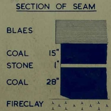
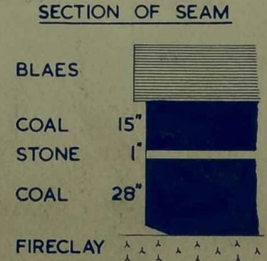
Due to the fact that the Splint outcrops in the immediate vicinity of the residential estate, the workings are bound to be very, very shallow. There are seam sections on the mine plan above, showing the worked seam to range between 21" to 42" (0.53-1.07m), as shown below.

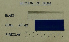
Extracted Splint seam thickness as shown on mine plan
Wallsend
The mine plans do not show mine workings in Wallsend Coal beneath the affected residential estate in Coalsnaughton. However, there are numerous roadways shown in the vicinity, where the Wallsend and the Main were extracted together.
Mine workings in Coalsnaughton Main Coal
We have already discussed the locations of the coal outcrops, the thickness of the seams, the vertical distance between the seams and the fact that the highest worked seam, the Splint, has been worked extensively in the area from ancient times. The Coalsnaughton Main Coal has also been worked extensively in the area, as shown in the four plans I have georeferenced and merged together below.
Georeferenced and merged plans of Coalsnaughton Main mine workings in Coalsnaughton with reference 26/9095, 26/9096, 26/9295 and 26/9296. (Source: Scotland's People).
On the plan you'll see lots of mineworkings of different ages. The oldest recorded one is the one beneath Coalsnaughton, with two "Old Shafts" used to access those workings and the edges of the mine workings shown dated 1857 and 1862. The Crankie Shaft, which also appears to intersect the workings, is shown as "Filled ip prior to 1961". There are yet older workings just to the east of those mine workings where it says "Waste" where the miners back in the mid 1800s must have decided not to go into (likely no access and probably not safe either). There are also more ancient workings just to the south of the 1800's workings, but parts of them were surveyed, as stated on the plan: “Old workings surveyed 5th May 1949”. Looking at these, it gives us an indication of the type of workings they were, traditional room and pillar workings where the extracted rooms were about 3m wide and the pillars somewhat variable but many I measured to be about 8m wide. The problem with pillar and stall workings is that the pillars can degrade over time and if they eventually collapse, then they can cause delayed subsidence (normally subsidence would happen more or less as soon as the seams were worked, particularly when no pillars were left in place).
Then to the east of Coalsnaughton, you can see a similar pillar and stall pattern of workings, where the coal was extracted in the early 1900s still by traditional means, but about a decade later they seem to have moved onto total extraction, where no pillars were left in place (shown as all shaded red. Then the workings furthest to the west have been mined using the more modern and industrial scale longwall mining, where everything was taken out across panel shaped areas. There are some good seam records of seam levels for those workings (level is based on 10,000 feet above ordnance datum - so if the number is lower than 10,000 feet then the level is that many feet below ordnance datum).
Where the Main was only extracted, the thickness was about 1.09 - 1.32m but where it was extracted with the Wallsend, it could have been anywhere between 2.30m to 6.30m! Another observation from the seam section is that the roof rock above the Coalsnaughton Main is well and truly rubbish, as "blaes" means a laminated friable mudstone, which breaks down very easily, so even if the Wallsend was not extracted at the same time, the roof above the workings in Main would have gradually crumbled and void migration upwards.
Extracted seam section of the Main seam.
However, one concerning detail about the Main is that if you have a look at mine plans for the Wallsend seam, it is shown to be extracted with the Main in roadways, making the voids positively massive, up to about 6m in thickness. These Wallsend roadways are not shown anywhere within Coalsnaughton town, but all around it. However, as the mine workings beneath Coalsnaughton are very old, do not show any precise details like the positions of roadways, thinknesses of the seam in that specific place or any elevation data, it may well be possible the Wallsend, too, was extracted along roadways in the Main within this area. In which case, the 22m vertical distance between the Main and the Splint, and 18m between Wallsend and Splint, which is definitely not sufficient cover. The fact that the roof rock of the Wallsend is also an interlaminated ("fakey") sandstone means that the voids may have stood open for a good while before eventually collapsing.
Remediation of the site
Back in 2008, prior to the residential estate being built, grouting works was undertaken and minimal details provided in the Mining Remediation Authority's website (formerly The Coal Authority). The report states that they remediated any mineworkings lying within a depth equivalent to a rock cover of 10 times the seam thickness (which is considered sufficient cover to choke the mine working voids so that the voids don't make their way to the surface). The average depth of the 1334 drill holes that were completed as part of the remediation works was 16m, based on the assumption that they needed at least 16m cover of rock above mine workings. Grouting was undertaken in the Mosie, Lower Five Foot and the Splint according to previously mentioned report, using a total of 2160 tonnes of grout that was injected into the mine workings. No grouting was undertaken in the Wallsend or Main seams.
The report also talks about probing and infilling of a shaft, which I presume is the one that's encountered within the residential estate. On the mine plans it's shown as an "Old Shaft" to the Main Coal and they state the depth is unknown. However, the remediation report from 2008 states that they confirmed the shaft to be 42m deep and loosely backfilled. The report states they treated it by drilling and pressure injection over the course of 6 days, when the shaft collapsed. They state that the void of the collapsed shaft was then backfilled using a stone and grout mixture and was then capped with 4m x 5m reinforced concrete cap.
Discussion
We have seen here however that wherever the Lower Five Foot coal has been worked, the rock cover between the Lower Five Foot and the Splint of 5.5m is insufficient (it should be 10m to ensure that void migration into the Lower Five Foot is prevented) and therefore the rock beneath the Lower Five Foot could collapse into the voids left behind in the Splint, potentially increasing the total void of the Lower Five Foot to 2.5m instead of 1.0-1.5m. Therefore, in reality, one would assume that drill holes of at least 26 m would have been needed to secure sufficient cover ratio of 25m, assuming you need 10x the void height to ensure it doesn't migrate upwards to the surface.
Furthermore, if there are any areas where the Main was extracted alongside the Wallsend, these voids would be significant - up to 6m in height, probably more likely along roadways, as suggested by mine plans of other areas nearby. In this instance of roadways, industry guidelines suggest that you'd need about 7 times the thickness of the extracted seam to ensure voids don't migrate up to the next seam above it (in which case if it did migrate, it would increase the size of the void in the seam above). That's then 42m needed, but as we've seen above, the vertical separation between the Splint and Wallsend is a mere 18m.
Where the Wallsend wasn't extracted, it looks a lot better, as the maximum extracted thickness of the Main on its own was "just" 1.3m while the seam separation is 22m, which would typically be considered sufficient (you'd only really need 13m). However, there are some caveats due to the fact that the roof rock just above the Main is likely really rubbish (very friable mudstone that breaks into tiny chips as it weathers), therefore a lot more roof rock waste could accumulate in the mine workings before they'd get clogged up. Furthermore, there's always the possibility of wide spread pillar failure in the old stoop and room workings.
Follow us on Social Media for travel updates and top tips!
© 2026. All rights reserved.
I can't recommend Pimsleur enough for learning a new language! If you don't believe me, try for your self - All Access FREE for 7 days on signup.
This website and domain is hosted by Hostinger and made easily with Hostinger website builder. Get yours from £1.99 GBP per month here!